File:Homo Sapiens in Europe - solutrean distribution map-de.svg
Jump to navigation
Jump to search

Size of this PNG preview of this SVG file: 800 × 529 pixels. Other resolutions: 320 × 211 pixels | 640 × 423 pixels | 1,024 × 677 pixels | 1,280 × 846 pixels | 2,560 × 1,692 pixels | 1,150 × 760 pixels.
Original file (SVG file, nominally 1,150 × 760 pixels, file size: 59 KB)
Captions
Captions
Add a one-line explanation of what this file represents
Summary[edit]
| Description |
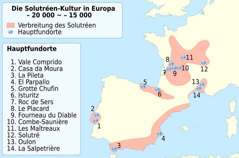
Deutsch: Verbreitung der Solutréen-Kultur des Homo sapiens in Europa zwischen -20 000 und 15 000.
Français : Carte de localisation de la culture Homo Sapiens du Solutréen, environ entre -20 000 et 15 000. English: Location map of Homo Sapiens during Solutrean culture, between 22,000 ~ 17,000 BP. French version. |
| Date | (UTC) |
| Source |
This file was derived from: Homo Sapiens in Europe - solutrean distribution map-fr.svg: |
| Author |
|
| This is a retouched picture, which means that it has been digitally altered from its original version. Modifications: traduction allemand / German translation. The original can be viewed here: Homo Sapiens in Europe - solutrean distribution map-fr.svg:
|
Licensing[edit]
I, the copyright holder of this work, hereby publish it under the following licenses:
| This file is licensed under the Creative Commons Attribution-Share Alike 3.0 Unported license. | ||
| ||
| This licensing tag was added to this file as part of the GFDL licensing update. |

|
Permission is granted to copy, distribute and/or modify this document under the terms of the GNU Free Documentation License, Version 1.2 or any later version published by the Free Software Foundation; with no Invariant Sections, no Front-Cover Texts, and no Back-Cover Texts. A copy of the license is included in the section entitled GNU Free Documentation License. |
You may select the license of your choice.
Original upload log[edit]
This image is a derivative work of the following images:
- File:Homo_Sapiens_in_Europe_-_solutrean_distribution_map-fr.svg licensed with Cc-by-sa-3.0-migrated, GFDL
- 2009-11-08T19:51:35Z Sémhur 1150x760 (59967 Bytes) == {{int:filedesc}} == {{Information |Description= {{en|Location map of Homo Sapiens during [[:en:Solutrean|Solutrean]] culture, between 22,000 ~ 17,000 BP. French version.}} {{fr|Carte de localisation de la culture Homo Sapi
Uploaded with derivativeFX
File history
Click on a date/time to view the file as it appeared at that time.
| Date/Time | Thumbnail | Dimensions | User | Comment | |
|---|---|---|---|---|---|
| current | 10:56, 19 August 2012 | | 1,150 × 760 (59 KB) | Furfur (talk | contribs) | == {{int:filedesc}} == {{Information |Description={{de|Verbreitung der Solutréen-Kultur des ''Homo sapiens'' in Europa zwischen -20 000 und 15 000.}} {{fr|Carte de localisation de la culture Homo Sapiens du [[:fr:Solutrée... |
You cannot overwrite this file.
File usage on Commons
The following page uses this file:
File usage on other wikis
The following other wikis use this file: