File:Hout Bay and Oudekraal dive sites.png
Jump to navigation
Jump to search

Size of this preview: 421 × 600 pixels. Other resolutions: 168 × 240 pixels | 337 × 480 pixels | 539 × 768 pixels | 1,128 × 1,607 pixels.
Original file (1,128 × 1,607 pixels, file size: 143 KB, MIME type: image/png)
Captions
Captions
Add a one-line explanation of what this file represents
Summary[edit]
| Description |
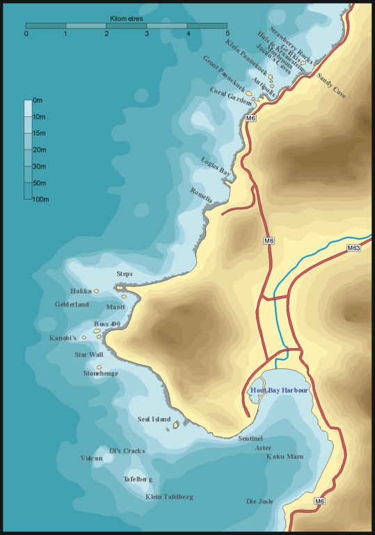
English: Map showing the location of dive sites from Oudekraal to Hout Bay, Cape Town. |
| Date | |
| Source | P.B.Southwood |
| Author | Peter Southwood |
Licensing[edit]
User: (WT-shared) Pbsouthwood at wts wikivoyage, the copyright holder of this work, hereby publishes it under the following license:
This file is licensed under the Creative Commons Attribution-Share Alike 3.0 Unported license.
Attribution: User: (WT-shared) Pbsouthwood at wts wikivoyage
- You are free:
- to share – to copy, distribute and transmit the work
- to remix – to adapt the work
- Under the following conditions:
- attribution – You must give appropriate credit, provide a link to the license, and indicate if changes were made. You may do so in any reasonable manner, but not in any way that suggests the licensor endorses you or your use.
- share alike – If you remix, transform, or build upon the material, you must distribute your contributions under the same or compatible license as the original.
Original upload log[edit]
| This file was imported from Wikivoyage WTS. |
The original description page was here. All following user names refer to wts.wikivoyage-old.
org:
- 2009-08-07 18:42 (WT-shared) Pbsouthwood[dead link] 1128×1607 (146030 bytes) {{Imagecredit|credit=Peter Southwood|captureDate=2009|location=Cape town|source=P.B.Southwood|caption=|description=Map showing the location (Import from wikitravel.org/shared)
- 2009-08-07 19:02 (WT-shared) Pbsouthwood[dead link] 1128×1607 (146030 bytes) {{Imagecredit|credit=Peter Southwood|captureDate=2009|location=Cape Town|source=P.B.Southwood|caption=|description=Map showing location of d (Import from wikitravel.org/shared)
File history
Click on a date/time to view the file as it appeared at that time.
| Date/Time | Thumbnail | Dimensions | User | Comment | |
|---|---|---|---|---|---|
| current | 19:17, 15 November 2012 | | 1,128 × 1,607 (143 KB) | MGA73bot2 (talk | contribs) | {{BotMoveToCommons|wts.oldwikivoyage|year={{subst:CURRENTYEAR}}|month={{subst:CURRENTMONTHNAME}}|day={{subst:CURRENTDAY}}}} == {{int:filedesc}} == {{Information |description=. Map showing the location of dive sites from Oudekraal to Hout Bay, Cape town... |
You cannot overwrite this file.
File usage on Commons
There are no pages that use this file.
File usage on other wikis
The following other wikis use this file: