File:Human presence, light pollution.jpg
Original file (2,500 × 1,934 pixels, file size: 1.81 MB, MIME type: image/jpeg)
Captions
Captions
Summary[edit]
| Description |
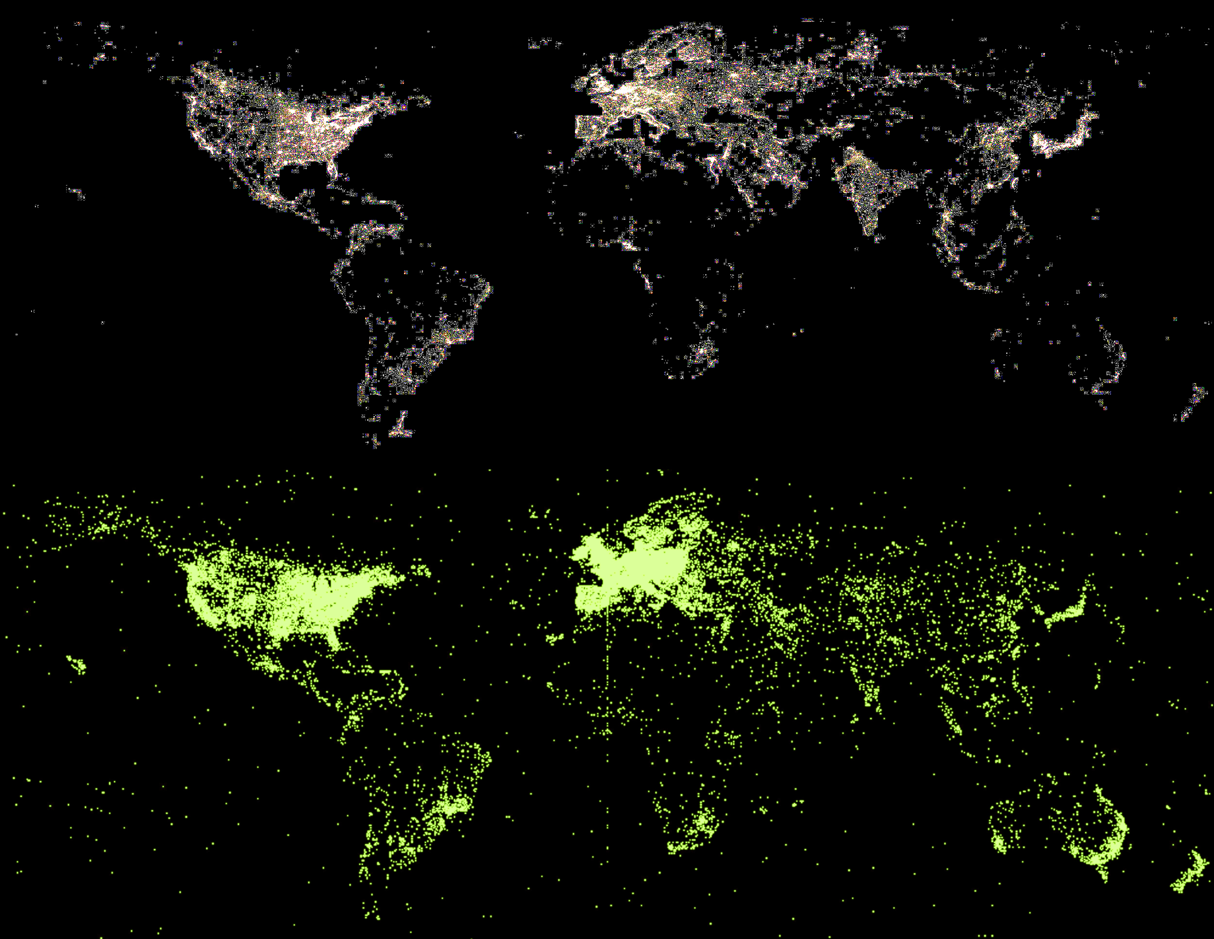
English: Levels of light pollution tend to correspond to where people are located.
This illustration shows two maps of the continents (excluding Antarctica) indicating different types of human activity. The upper map combines night time views for each part of the earth. The illumination indicates the presence of human populations affluent enough to generate light at night. "Earth at night" views can be misleading, because pollution caused by industrialisation and urbanisation can cause relative dimming, whereas - for example - high altitude mountain fires shine disproportionately brightly in the clear, thin air. This Earth Night Lights image is from <a href="http://www.oera.net/How2/TextureMaps2.htm" rel="nofollow">Tor Øra's website</a> which includes resources for CGI-ists. He also credits <a href="http://www.ngdc.noaa.gov/" rel="nofollow">NGDS</a> / <a href="http://www.noaa.gov/" rel="nofollow">NOAA</a> / <a href="http://en.wikipedia.org/wiki/Defense_Meteorological_Satellite_Program" rel="nofollow">DMSP</a> who presumably measured, collected and processed the original data. The lower map shows the self declared locations of users of <a href="http://www.heavens-above.com/worldvisits.aspx?lat=0&lng=0&loc=Unspecified&alt=0&tz=CET" rel="nofollow">Heavens Above</a>, a website that provides astronomical information customised to geographical locations. (For example, localised information relating to viewing satellite passes.) The information is effectively an aggregate of population density, internet access availability and usage, and the relative levels of interest in astronomy among internet users. This Earth Night Lights image dates from 2003 (or before); the Heavens Above image uses 30 days of data dating from July / August 2010. North America, Brazil, Europe, South Africa, Japan, Australia and New Zealand romp ahead in both night light production and astronomy website use. The most notable disparity between the two images is in India and Eastern China - both regions generate substantial amounts of light, but with lower usage of Heavens Above - although, to be fair, the website is English Language. Central Africa appears depressingly impoverished on both maps. Interestingly, many of the Heavens Above locations appear to be in the oceans. These are either user entry errors, islands, or bored cargo ship navigators enjoying the clean, clear, maritime night sky. There is also a "suspicious" seam down the Greenwich Meridian (Longitude 0°). <a href="http://en.wikipedia.org/wiki/Light_pollution" rel="nofollow">Light pollution</a> annoys astronomers. They will no doubt be disheartened to learn that human beings are addicted to light, spending 0.7% of their income on light, regardless of income or technology. The development of cheaper, more efficient, LED lighting <a href="https://www.theregister.co.uk/2010/08/25/led_save_energy_not/" rel="nofollow">is predicted to result in more light... </a> [or read the free academic paper <a href="http://iopscience.iop.org/0022-3727/43/35/354001" rel="nofollow">"Solid-state lighting: an energy-economics perspective"</a> directly] Part of a <a href="https://www.flickr.com/photos/dominicspics/sets/72157624781879918/">set</a> / <a href="https://www.flickr.com/photos/dominicspics/sets/72157624781879918/show/">Slideshow</a> featuring images of stars, the night sky and the occasional meteor taken during the peak of the Perseid Meteor Shower in August 2010.Русский: Интенсивность светового загрязнения зависит от расположения на Земле людей.
Две приведённые карты мира (без антарктиды) показывают разные типы человеческой активности. Верхняя карта показывает освещённость различных частей Земли в ночное время. Нижняя карта - обращение к сайту Heavens Above любителей астрономии. |
||
| Date | |||
| Source | Flickr: Human Presence / Light Pollution | ||
| Author | Dominic Alves | ||
| Permission (Reusing this file) |
This file is licensed under the Creative Commons Attribution 2.0 Generic license.
|
File history
Click on a date/time to view the file as it appeared at that time.
| Date/Time | Thumbnail | Dimensions | User | Comment | |
|---|---|---|---|---|---|
| current | 09:57, 23 October 2011 | | 2,500 × 1,934 (1.81 MB) | Flickr upload bot (talk | contribs) | Uploaded from http://flickr.com/photo/64097751@N00/4915205329 using Flickr upload bot |
You cannot overwrite this file.
File usage on Commons
There are no pages that use this file.
File usage on other wikis
The following other wikis use this file:
- Usage on ru.wikipedia.org