File:Cessna 150 at Iba Airport 9319 12.jpg
(Redirected from File:IbaAirportjf9319 12.JPG)

Size of this preview: 800 × 600 pixels. Other resolutions: 320 × 240 pixels | 640 × 480 pixels | 1,024 × 768 pixels | 1,280 × 960 pixels | 2,560 × 1,920 pixels | 4,608 × 3,456 pixels.
Original file (4,608 × 3,456 pixels, file size: 6.42 MB, MIME type: image/jpeg)
Captions
Captions
Add a one-line explanation of what this file represents
Summary[edit]
| Description |
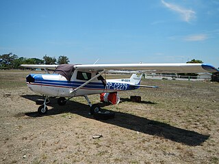
English: These are photos of the---Iba Pagasa Synoptic Station, Brgy. Lipay-Dingin, Iba Airport, the Aviation schools and some planes flying and escending, the Civil Aviation Authority of the Philippines inside the Airport, and PAGASA station & Iba Airfield ---Iba Airfield[1]Iba Airfield is a former United States Army Air Forces airfield on Luzon in the Philippines. It was overrun by the Imperial Japanese Army during the Battle of the Philippines (1942).[2][3] [4] Maps of Iba Airfield - Philippines 2013[5]Location Located near Iba on the western coast of Luzon. Also known as "Iba Field" Construction Pre-war airfield based American Pursuit Squadrons. American Units Based at Iba 24th PG, 3rd PS (P-40E) December 1941[6][7]Iba Airfield - Airfield in Panibuatan, Zambales, Philippines: Airfield in Panibuatan Latitude/Longitude: N 15° 19' 38.28" E 119° 58' 0.84" (15.32730, 119.96690) Time Zone: Asia/Manila UTC/GMT+08:00 ------ Iba Airport[8], a small feeder airport with a 900-metre (3,000 ft) runway located along the coast of Iba.[9]CAAP Official Website - Office List[10]Coordinates: 15°19'33"N 119°58'6"E[11] -------Civil Aviation Authority of the Philippines[12]The Philippines' Civil Aviation Authority formerly Air Transportation Office, abbreviated as CAAP, is an agency of the Philippine government under the Department of Transportation and Communications. It is the national aviation authority of the Philippines, responsible for implementing policies on civil aviation to assure safe, economic and efficient air travel.[2] The agency also investigates aviation accidents via its Aircraft Accident Investigation and Inquiry Board.[3] The agency's main office is in Pasay City.[13]CAAP Official Website - Office List[14]List of airports in the Philippines[15] ---- Iba, Zambales[16] is a municipality and capital of the province of Zambales[17]Area: 153.38 km² ZIP Code: 2201 in the Philippines and is politically subdivided into 14 barangays.[18][19] As of the 2010 Philippine census, Iba has a population of 46,761 people with an income classification of second class.[20] ---Iba Pagasa Synoptic Station, Brgy. Lipay-Dingin, DOST,[21]Department of Science and Technology (Philippines)[22] PAGSA -[23] Zambales PAGASA Synoptic Station, located in Iba Zambales airport provide weather data to the locality and air port data. Coordinates: 15°19'33"N 119°58'9"EWebsite Philippine Atmospheric, Geophysical and Astronomical Services Administration[24]The Philippine Atmospheric, Geophysical and Astronomical Services Administration (Filipino: Pangasiwaan ng Palingkurang Atmosperiko, Heopisikal at Astronomiko ng Pilipinas, abbreviated as PAGASA, which means "hope" in the Tagalog word pag-asa) is a Philippine national institution dedicated to provide flood and typhoon warnings, public weather forecasts and advisories, meteorological, astronomical, climatological, and other specialized information and services primarily for the protection of life and property and in support of economic, productivity and sustainable development. The government agency was created on 8 December 1972 by virtue of Presidential Decree No. 78 reorganizing the Philippine Weather Bureau into PAGASA.[25] Zambales[26]-----[N.B. From Bulacan province about 11:00 a.m. of May 2, Thurday, 2013; I arrived at Cabangan, Zambales about 3 p.m. and captured the town hall, San Isidro beach and St. Rose of Lima Church, inter alia and the busy Public market; I arrived at dusk at Iba, Zambales and took night photo of the Capitolio; on May 3, 2013, 1st Friday, I began photos of Iba, its Capitolio, Cathedral, Municipio, Schools, Sports Complex and then Botolan and I finished photography of the town at 3:25 p.m. amid burning sun, scorching heat at 37 deg. centigrade. The journey from Iba and Botolan, Zambales to Bulacan is more than 7 hours by bus.] |
| Date | |
| Source | Own work |
| Author | Ramon FVelasquez |
Licensing[edit]
I, the copyright holder of this work, hereby publish it under the following license:
This file is licensed under the Creative Commons Attribution-Share Alike 3.0 Unported license.
- You are free:
- to share – to copy, distribute and transmit the work
- to remix – to adapt the work
- Under the following conditions:
- attribution – You must give appropriate credit, provide a link to the license, and indicate if changes were made. You may do so in any reasonable manner, but not in any way that suggests the licensor endorses you or your use.
- share alike – If you remix, transform, or build upon the material, you must distribute your contributions under the same or compatible license as the original.
File history
Click on a date/time to view the file as it appeared at that time.
| Date/Time | Thumbnail | Dimensions | User | Comment | |
|---|---|---|---|---|---|
| current | 10:44, 4 May 2013 | | 4,608 × 3,456 (6.42 MB) | Ramon FVelasquez (talk | contribs) | User created page with UploadWizard |
You cannot overwrite this file.
File usage on Commons
The following 2 pages use this file: