File:InternetPenetrationWorldMap.svg
Jump to navigation
Jump to search

Size of this PNG preview of this SVG file: 800 × 410 pixels. Other resolutions: 320 × 164 pixels | 640 × 328 pixels | 1,024 × 525 pixels | 1,280 × 657 pixels | 2,560 × 1,313 pixels | 1,035 × 531 pixels.
Original file (SVG file, nominally 1,035 × 531 pixels, file size: 1.31 MB)
Captions
Captions
Add a one-line explanation of what this file represents
Summary[edit]
| Description |
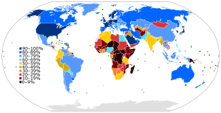
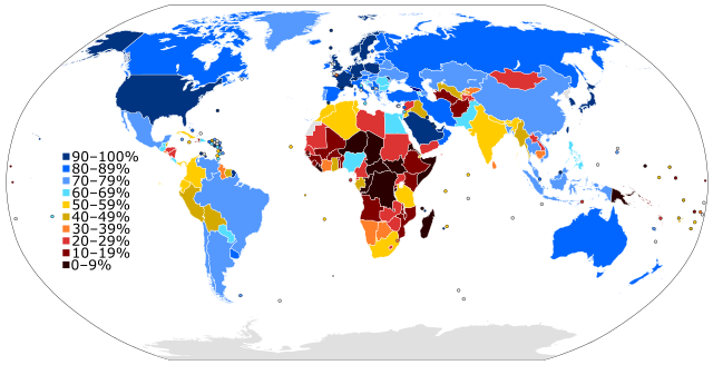
English: A world map colored to show the level of Internet penetration (number of Internet users as a percentage of a country's population). |
| Date | 24 April 2012 (updated 2023) |
| Source |
Own work based on: figures from the Wikipedia:List of countries by number of Internet users article in the English Wikipedia, which is in turn based on figures from the International Telecommunications Union (ITU) for 2010 (updated to use figures for 2012 on 28 June 2013) (updated to 2016 on 5 Jan 2019) (updated to 2021/2022 on 17 June 2023). |
| Author | Jeff Ogden (W163) |
| Other versions |
This SVG map is an update of the older somewhat out-of-date PNG map: Internet Penetration.png |
| SVG development |
Licensing[edit]
I, the copyright holder of this work, hereby publish it under the following license:
This file is licensed under the Creative Commons Attribution-Share Alike 3.0 Unported license.
- You are free:
- to share – to copy, distribute and transmit the work
- to remix – to adapt the work
- Under the following conditions:
- attribution – You must give appropriate credit, provide a link to the license, and indicate if changes were made. You may do so in any reasonable manner, but not in any way that suggests the licensor endorses you or your use.
- share alike – If you remix, transform, or build upon the material, you must distribute your contributions under the same or compatible license as the original.
File history
Click on a date/time to view the file as it appeared at that time.
| Date/Time | Thumbnail | Dimensions | User | Comment | |
|---|---|---|---|---|---|
| current | 16:04, 17 June 2023 | | 1,035 × 531 (1.31 MB) | BlackShadowG (talk | contribs) | updated for 2023 per en:List of countries by number of Internet users |
| 21:17, 17 February 2022 |  | 1,035 × 531 (1.28 MB) | Enyavar (talk | contribs) | Reverted to version as of 20:40, 5 January 2019 (UTC) dear Jamie Tubers, please don't update one country for 2020 when the map's data source is based on 2015 | |
| 16:04, 8 February 2021 |  | 1,035 × 531 (1.29 MB) | Jamie Tubers (talk | contribs) | Reverted to version as of 20:43, 22 July 2020 (UTC) I updated the map according to the link right there in the "source" column of this page. | |
| 19:04, 25 January 2021 |  | 1,035 × 531 (1.28 MB) | Jeff G. (talk | contribs) | Reverted to version as of 20:40, 5 January 2019 (UTC) due to lack of explanation for update | |
| 20:43, 22 July 2020 |  | 1,035 × 531 (1.29 MB) | Jamie Tubers (talk | contribs) | update | |
| 20:40, 5 January 2019 |  | 1,035 × 531 (1.28 MB) | BMacZero (talk | contribs) | updated for 2016 en:List of countries by number of Internet users | |
| 20:11, 7 March 2017 |  | 1,035 × 531 (1.44 MB) | Amitchell125 (talk | contribs) | text quality impoved | |
| 02:22, 1 March 2017 |  | 1,035 × 531 (1.39 MB) | TriadicRelation98 (talk | contribs) | Updated for 2015 | |
| 00:32, 29 June 2013 |  | 863 × 443 (1.54 MB) | W163 (talk | contribs) | update to 2012 figures from the ITU as shown in the recently updated English Wikipedia article | |
| 14:27, 24 April 2012 |  | 863 × 443 (1.54 MB) | W163 (talk | contribs) |
You cannot overwrite this file.
File usage on Commons
The following 9 pages use this file:
- User:Chumwa/OgreBot/Travel and communication maps/2017 March 1-10
- User:Chumwa/OgreBot/Travel and communication maps/2019 January 1-10
- User:Chumwa/OgreBot/Travel and communication maps/2020 July 21-31
- User:Chumwa/OgreBot/Travel and communication maps/2021 February 1-9
- User:Chumwa/OgreBot/Travel and communication maps/2021 January 21-31
- User:Chumwa/OgreBot/Travel and communication maps/2022 February 10-18
- User:Chumwa/OgreBot/Travel and communication maps/2023 June 11-20
- Commons:Graphic Lab/Map workshop/Archive/2018
- File:Internet Penetration.png
File usage on other wikis
The following other wikis use this file:
- Usage on af.wikipedia.org
- Usage on an.wikipedia.org
- Usage on ar.wikipedia.org
- Usage on bg.wikipedia.org
- Usage on bn.wikiquote.org
- Usage on bs.wikipedia.org
- Usage on ca.wikipedia.org
- Usage on crh.wikipedia.org
- Usage on cs.wikipedia.org
- Usage on da.wikipedia.org
- Usage on de.wikipedia.org
- Usage on el.wikipedia.org
- Usage on en.wikipedia.org
- History of the Internet
- Internet
- Internet access
- Global digital divide
- Wikipedia:Systemic bias
- Portal:Internet
- User:SteveChervitzTrutane
- Internet in Africa
- Internet in the Philippines
- List of countries by number of Internet users
- Global Internet usage
- Wikipedia:Wikipedia Signpost/2012-10-22/WikiProject report
- Wikipedia:Wikipedia Signpost/Single/2012-10-22
- Talk:Digital divide/Archive 2
- Wikipedia:Graphics Lab/Map workshop/Archive/2016
- Stereotypes of Africa
- Usage on en.wikiquote.org
- Usage on es.wikipedia.org
- Usage on fa.wikipedia.org
- Usage on fi.wikipedia.org
- Usage on fr.wikipedia.org
View more global usage of this file.