File:Joplin-rain-map-2011.jpg
Jump to navigation
Jump to search

Size of this preview: 800 × 462 pixels. Other resolutions: 320 × 185 pixels | 830 × 479 pixels.
Original file (830 × 479 pixels, file size: 89 KB, MIME type: image/jpeg)
Captions
Captions
Add a one-line explanation of what this file represents
| Description |
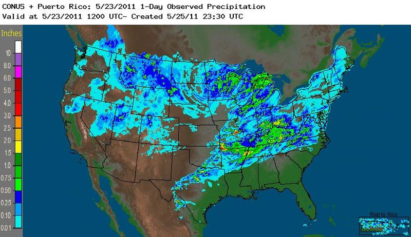
English: Weather Service map of precipitation from period 7 a.m (Central) May 22 to 7 am May 23, 2011 a period which the 2011 Joplin Tornado occurred. Rain amounts for Joplin are in red and yellow in the southwest corner of Missouri. |
|||||
| Date | ||||||
| Source |
http://water.weather.gov/precip/ (Select Archive: Daily under 1. Timeframe, and select 23 May 2011 in the relevant fields, permalink cannot work because it contains several square braces) Permalink: http://water.weather.gov/precip/index.php?yday=1316088000&yday_analysis=0&layer[]=0&layer[]=1&layer[]=4&timetype=D&loctype=STATE&units=engl&timeframe=current&timeYYYY=2011&timeMM=5&timeDD=23&product=observed&loc=conus |
|||||
| Author | NOAA National Weather Service | |||||
| Permission (Reusing this file) |
|
File history
Click on a date/time to view the file as it appeared at that time.
| Date/Time | Thumbnail | Dimensions | User | Comment | |
|---|---|---|---|---|---|
| current | 02:29, 2 July 2011 | | 830 × 479 (89 KB) | Americasroof (talk | contribs) |
You cannot overwrite this file.
File usage on Commons
There are no pages that use this file.