File:Jordan, administrative divisions - Nmbrs - colored.svg
Jump to navigation
Jump to search

Size of this PNG preview of this SVG file: 545 × 600 pixels. Other resolutions: 218 × 240 pixels | 436 × 480 pixels | 698 × 768 pixels | 931 × 1,024 pixels | 1,861 × 2,048 pixels | 1,088 × 1,197 pixels.
Original file (SVG file, nominally 1,088 × 1,197 pixels, file size: 196 KB)
Captions
Captions
Add a one-line explanation of what this file represents
Summary[edit]


.svg)


_(Paris_zoom).svg)
.svg)
,_administrative_divisions_-_de_-_colored_(multizoom).svg)
_-_colored.svg)
.svg)
,_administrative_divisions_-_Nmbrs_(multizoom).svg)
,_administrative_divisions_-_de_-_colored.svg)
_-_de_-_colored.svg)

.svg)

.svg)
Licensing[edit]
I, the copyright holder of this work, hereby publish it under the following license:
This file is licensed under the Creative Commons Attribution-Share Alike 3.0 Unported license.
- You are free:
- to share – to copy, distribute and transmit the work
- to remix – to adapt the work
- Under the following conditions:
- attribution – You must give appropriate credit, provide a link to the license, and indicate if changes were made. You may do so in any reasonable manner, but not in any way that suggests the licensor endorses you or your use.
- share alike – If you remix, transform, or build upon the material, you must distribute your contributions under the same or compatible license as the original.

|
I'd greatly appreciate, that you attribute this media file to Wikimedia Commons, if used outside Wikipedia or Commons. For use in publications such as books, newspapers, blogs, websites, please insert here the following line:
|
File history
Click on a date/time to view the file as it appeared at that time.
| Date/Time | Thumbnail | Dimensions | User | Comment | |
|---|---|---|---|---|---|
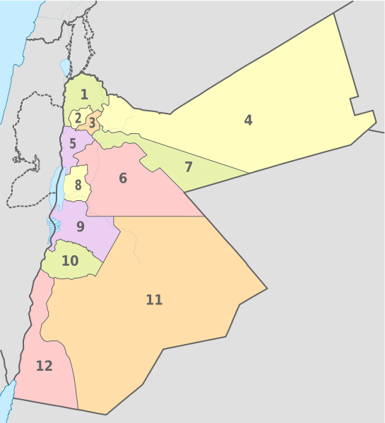
| current | 21:02, 11 August 2012 | | 1,088 × 1,197 (196 KB) | TUBS (talk | contribs) | == {{int:filedesc}} == {{Information |Description={{de|Karte der politischen Gliederung von XY (siehe Dateiname)}} {{en|Map of administrative divisions of XY (see filename)}} |Source={{own}}{{Adobe Illustrator}}{{Commonist}}{{AttribSVG|Amman_in_Jordan... |
You cannot overwrite this file.
File usage on Commons
There are no pages that use this file.
File usage on other wikis
The following other wikis use this file:
- Usage on ace.wikipedia.org
- Usage on is.wikipedia.org
- Usage on nn.wikipedia.org
- Usage on vep.wikipedia.org
- Usage on vi.wikipedia.org
Categories:
- SVG labeled maps of administrative divisions of Jordan (location map scheme)
- Maps of subdivisions of Jordan
- SVG labeled maps of administrative divisions of countries of Asia (location map scheme) (numbers only)
- SVG labeled maps of administrative divisions of countries of Asia (location map scheme) (colored scheme)