File:KD 5SFG Camp.jpg
Jump to navigation
Jump to search

Size of this preview: 494 × 599 pixels. Other resolutions: 198 × 240 pixels | 615 × 746 pixels.
Original file (615 × 746 pixels, file size: 115 KB, MIME type: image/jpeg)
Captions
Captions
Add a one-line explanation of what this file represents
Summary[edit]

|
This file was moved to Wikimedia Commons from en.wikipedia using a bot script. All source information is still present. It requires review. Additionally, there may be errors in any or all of the information fields; information on this file should not be considered reliable and the file should not be used until it has been reviewed and any needed corrections have been made. Once the review has been completed, this template should be removed. For details about this file, see below. Check now! |
| Description |
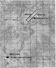
English: This map was taken from the sourced material below; I added the position of Kham duc and Ngok Tavak by marking the relevant areas, because the map is of poor quality. |
| Date | Unknown date |
| Source | From Alan Gropman. (1985). Airpower and Airlift Evacuation of Kham Duc. Washington D.C: Office of Air Force History. |
| Author | The photograph belong to the sourced material. |
Licensing[edit]
This image or file is a work of a U.S. Air Force Airman or employee, taken or made as part of that person's official duties. As a work of the U.S. federal government, the image or file is in the public domain in the United States.
|
 |
Original upload log[edit]
Transferred from en.wikipedia to Commons by Shashenka using CommonsHelper.
The original description page was here. All following user names refer to en.wikipedia.
- 2011-02-04 13:01 Canpark 615×746× (117689 bytes) {{Information |Description = This map was taken from the sourced material below; I added the position of Kham duc and Ngok Tavak by marking the relevant areas, because the map is of poor quality. |Source = From Alan Gropman. (1985). Airpower
File history
Click on a date/time to view the file as it appeared at that time.
| Date/Time | Thumbnail | Dimensions | User | Comment | |
|---|---|---|---|---|---|
| current | 04:08, 5 April 2012 | | 615 × 746 (115 KB) | File Upload Bot (Magnus Manske) (talk | contribs) | Transfered from en.wikipedia by User:Shashenka using CommonsHelper |
You cannot overwrite this file.
File usage on Commons
There are no pages that use this file.
File usage on other wikis
The following other wikis use this file:
- Usage on en.wikipedia.org