File:Karte der S-Bahn Magdeburg.svg
Jump to navigation
Jump to search

Size of this PNG preview of this SVG file: 309 × 600 pixels. Other resolutions: 123 × 240 pixels | 247 × 480 pixels | 395 × 768 pixels | 527 × 1,024 pixels | 1,055 × 2,048 pixels | 906 × 1,759 pixels.
Original file (SVG file, nominally 906 × 1,759 pixels, file size: 402 KB)
Captions
Captions
Add a one-line explanation of what this file represents
Summary[edit]
| Description |
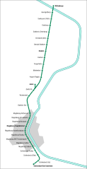
Deutsch: Karte der S-Bahn Magdeburg. |
| Source | Own work |
| Author | Arbalete |
| Permission (Reusing this file) |
I, the copyright holder of this work, hereby publish it under the following license: This file is licensed under the Creative Commons Attribution-Share Alike 3.0 Unported license.
|
File history
Click on a date/time to view the file as it appeared at that time.
| Date/Time | Thumbnail | Dimensions | User | Comment | |
|---|---|---|---|---|---|
| current | 21:01, 19 January 2017 | | 906 × 1,759 (402 KB) | Arbalete (talk | contribs) | Aktualisiere |
| 11:45, 19 February 2014 |  | 3,292 × 4,571 (31 KB) | Arbalete (talk | contribs) | User created page with UploadWizard |
You cannot overwrite this file.
File usage on Commons
The following 5 pages use this file:
- User:Chumwa/OgreBot/Potential transport maps/2017 January 11-20
- User:Chumwa/OgreBot/Public transport information/2017 January 11-20
- User:Chumwa/OgreBot/Transport Maps/2017 January 11-20
- User:Chumwa/OgreBot/Travel and communication maps/2017 January 11-20
- User:Nordlicht8/Rail Germany/2014 February 19-28