File:Kermadec Plate map-fr.png
Jump to navigation
Jump to search
No higher resolution available.
Kermadec_Plate_map-fr.png (497 × 441 pixels, file size: 150 KB, MIME type: image/png)
Captions
Captions
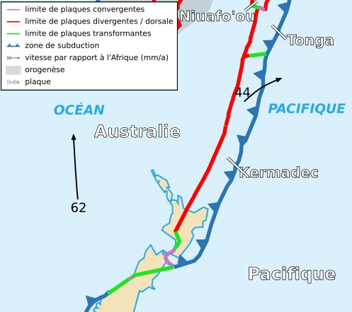
Geological map of the Kermadec tectonic plate and the New Zealand region; violet = convergent plate bounderies; red = divergent plate bounderies/ridge; green = transform zones; dark blue = subduction zones
| Description |
Français : Carte de la plaque des Kermadec English: Map of the Kermadec Plate |
| Date | |
| Source | Cropped version by myself of Image:Tectonic_plates_boundaries_detailed-fr.svg created by Sting under CC-BY-SA |
| Author | Sting and Rémih |
| Permission (Reusing this file) |
This file is licensed under the Creative Commons Attribution-Share Alike 2.5 Generic license.
|
| Other versions |
Scaled version of  |
File history
Click on a date/time to view the file as it appeared at that time.
| Date/Time | Thumbnail | Dimensions | User | Comment | |
|---|---|---|---|---|---|
| current | 22:59, 18 November 2006 | | 497 × 441 (150 KB) | Rémih (talk | contribs) | {{Information |Description={{fr|Carte de la plaque des Kermadec}}{{en|Map of the Kermadec Plate}} |Source=Cropped version by myself of Image:Tectonic_plates_boundaries_detailed-fr.svg created by Sting under CC-BY-SA |Date=18/11/2006 |A |
You cannot overwrite this file.
File usage on Commons
There are no pages that use this file.
File usage on other wikis
The following other wikis use this file:
- Usage on az.wikipedia.org
- Usage on ca.wikipedia.org
- Usage on cs.wikipedia.org
- Usage on en.wikipedia.org
- Usage on es.wikipedia.org
- Usage on eu.wikipedia.org
- Usage on fr.wikipedia.org
- Usage on it.wikipedia.org
- Usage on ja.wikipedia.org
- Usage on ko.wikipedia.org
- Usage on pl.wikipedia.org
- Usage on ru.wikipedia.org
- Usage on uk.wikipedia.org
- Usage on zh.wikipedia.org