File:Kreis Euskirchen Political.png
Jump to navigation
Jump to search

Size of this preview: 600 × 600 pixels. Other resolutions: 240 × 240 pixels | 480 × 480 pixels | 768 × 768 pixels | 1,024 × 1,024 pixels | 1,600 × 1,600 pixels.
Original file (1,600 × 1,600 pixels, file size: 242 KB, MIME type: image/png)
Captions
Captions
Add a one-line explanation of what this file represents
Summary[edit]
| Description |
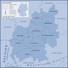
Deutsch: Kreis Euskirchen, politische Karte mit Städten/Gemeinden und Nachbarkreisen |
||
| Date | |||
| Source | eigene Zeichnung | ||
| Author | Wikoli | ||
| Other versions |
|

Licensing[edit]
This file is licensed under the Creative Commons Attribution-Share Alike 2.0 Germany license.
- You are free:
- to share – to copy, distribute and transmit the work
- to remix – to adapt the work
- Under the following conditions:
- attribution – You must give appropriate credit, provide a link to the license, and indicate if changes were made. You may do so in any reasonable manner, but not in any way that suggests the licensor endorses you or your use.
- share alike – If you remix, transform, or build upon the material, you must distribute your contributions under the same or compatible license as the original.

Original upload log[edit]
Transferred from de.wikipedia to Commons by Rosenzweig using CommonsHelper.
The original description page was here. All following user names refer to de.wikipedia.
- 2007-09-14 05:06 Wikoli 1600×1600× (247308 bytes) {{Information |Beschreibung = Kreis Euskirchen, politische Karte mit Städten/Gemeinden und Nachbarkreisen |Quelle = eigene Zeichnung |Urheber = [[Benutzer:Wikoli|Wikoli]] |Datum = 14. Sept. 2007 |Genehmigung = |Andere Versionen = |Anmerkungen = }}
File history
Click on a date/time to view the file as it appeared at that time.
| Date/Time | Thumbnail | Dimensions | User | Comment | |
|---|---|---|---|---|---|
| current | 17:55, 20 December 2010 | | 1,600 × 1,600 (242 KB) | File Upload Bot (Magnus Manske) (talk | contribs) | {{BotMoveToCommons|de.wikipedia|year={{subst:CURRENTYEAR}}|month={{subst:CURRENTMONTHNAME}}|day={{subst:CURRENTDAY}}}} {{Information |Description={{de|Kreis Euskirchen, politische Karte mit Städten/Gemeinden und Nachbarkreisen}} |Source=Transferred from |
You cannot overwrite this file.
File usage on Commons
There are no pages that use this file.
File usage on other wikis
The following other wikis use this file:
- Usage on de.wikipedia.org