File:Labastide Lame Magdalenien (4).jpg
Jump to navigation
Jump to search

Size of this preview: 800 × 481 pixels. Other resolutions: 320 × 193 pixels | 640 × 385 pixels | 1,024 × 616 pixels | 1,280 × 770 pixels | 2,560 × 1,540 pixels | 3,968 × 2,387 pixels.
Original file (3,968 × 2,387 pixels, file size: 1.81 MB, MIME type: image/jpeg)
Captions
Captions
Add a one-line explanation of what this file represents
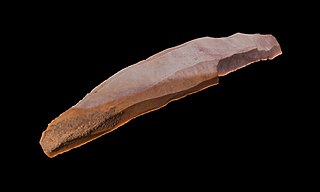
Flint blades, Magdalenian IV, Labastide, Hautes-Pyrénées, France
Summary[edit]
| Grottes de Labastide
|
||||||||||||||||||||||||
|---|---|---|---|---|---|---|---|---|---|---|---|---|---|---|---|---|---|---|---|---|---|---|---|---|
| Title |
Grottes de Labastide |
.jpg) | ||||||||||||||||||||||
| Object type |
cave with prehistoric art |
|||||||||||||||||||||||
| Description | ||||||||||||||||||||||||
| Date |
between - 17 000 and - 9 000 BP |
|||||||||||||||||||||||
| Medium | flint | |||||||||||||||||||||||
| Dimensions | 17.1 × 2.9 × 2 cm (6.7 × 1.1 × 0.7 in) | |||||||||||||||||||||||
| Collection |
|
|||||||||||||||||||||||
| Accession number |
MHNT.PRE.2009.0.207.5 |
|||||||||||||||||||||||
| Object location |
|
|||||||||||||||||||||||
| Object history |
Place of discovery: Labastide, Hautes-Pyrénées, France. Former collection of André Glory, Robert & Georges Simonet. |
|||||||||||||||||||||||
| Source/Photographer |
Didier Descouens, 9 October 2010 I, the copyright holder of this work, hereby publish it under the following license: This file is licensed under the Creative Commons Attribution-Share Alike 4.0 International license.
|
|||||||||||||||||||||||
| Other versions |
|
|||||||||||||||||||||||


.jpg)
.jpg)
.jpg&action=edit§ion=1)
.jpg¶ms=043.032800_N_0000.345833_E_globe:Earth_class:object_type:object__&language=en)
| Camera location | | View this and other nearby images on: OpenStreetMap |
|---|
.jpg¶ms=043.593897_N_0001.449230_E_globe:Earth_type:camera__&language=en)

|
This document was made as part of the Projet Phoebus.
|
File history
Click on a date/time to view the file as it appeared at that time.
| Date/Time | Thumbnail | Dimensions | User | Comment | |
|---|---|---|---|---|---|
| current | 13:24, 13 October 2010 | | 3,968 × 2,387 (1.81 MB) | Archaeodontosaurus (talk | contribs) | {{Information |Description={{en|1=x}} |Source={{own}} |Author=Archaeodontosaurus |Date= |Permission= |other_versions= }} |
You cannot overwrite this file.
File usage on Commons
The following 5 pages use this file:
.jpg&oldid=618123385)