File:Lake Ontario - Southwick Beach SP locator.jpg
Jump to navigation
Jump to search
No higher resolution available.
Lake_Ontario_-_Southwick_Beach_SP_locator.jpg (653 × 379 pixels, file size: 91 KB, MIME type: image/jpeg)
Captions
Captions
Add a one-line explanation of what this file represents
Summary[edit]
| Description |
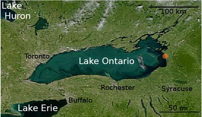
English: Satellite photograph from the SeaWiFS Project, public domain. The photograph has been cropped, and text labels added to serve as a locator image for the w:Southwick Beach State Park article. |
| Date | |
| Source | Annotated and cropped version of public domain Commons image Image:Lakes Erie and Ontario - satellite.jpg |
| Author | The SeaWiFS project, annotation by Wikipedia editor Easchiff |
Licensing[edit]
I, the copyright holder of this work, hereby publish it under the following license:

|
Permission is granted to copy, distribute and/or modify this document under the terms of the GNU Free Documentation License, Version 1.2 or any later version published by the Free Software Foundation; with no Invariant Sections, no Front-Cover Texts, and no Back-Cover Texts. A copy of the license is included in the section entitled GNU Free Documentation License. |
| This file is licensed under the Creative Commons Attribution-Share Alike 3.0 Unported license. | ||
| ||
| This licensing tag was added to this file as part of the GFDL licensing update. |
| This image is from the Sea-viewing Wide Field-of-view Sensor (SeaWiFS) Project and more than 5 years old.
Satellite data captured by the SeaWIFS sensor are released into the public domain 5 years after capture. Data less than five years old can be re-used only for educational or scientific purposes; any commercial use of such images must be coordinated with GeoEye. [1] |
| This work has been released into the public domain by its copyright holder, GeoEye. This applies worldwide. In some countries this may not be legally possible; if so: GeoEye grants anyone the right to use this work for any purpose, without any conditions, unless such conditions are required by law.
|
File history
Click on a date/time to view the file as it appeared at that time.
| Date/Time | Thumbnail | Dimensions | User | Comment | |
|---|---|---|---|---|---|
| current | 01:05, 9 September 2008 | | 653 × 379 (91 KB) | Easchiff (talk | contribs) | {{Information |Description= |Source= |Date= |Author= |Permission= |other_versions= }} |
| 01:01, 9 September 2008 |  | 650 × 380 (90 KB) | Giggy (talk | contribs) | Reverted to version as of 05:16, 7 September 2008 - looks better without all the whitespace I think. | |
| 01:00, 9 September 2008 |  | 960 × 720 (61 KB) | Easchiff (talk | contribs) | {{Information |Description= |Source= |Date= |Author= |Permission= |other_versions= }} | |
| 05:16, 7 September 2008 |  | 650 × 380 (90 KB) | Easchiff (talk | contribs) | {{Information |Description={{en|1=Satellite photograph from the SeaWiFS Project, public domain. The photograph has been cropped, and text labels added to serve as a locator image for the w:Southwick Beach State Park article.}} |Source=Annotated and cr |
You cannot overwrite this file.
File usage on Commons
There are no pages that use this file.
File usage on other wikis
The following other wikis use this file:
- Usage on en.wikipedia.org
- Usage on www.wikidata.org