File:Location of Katlas caldera.png
Jump to navigation
Jump to search

Size of this preview: 683 × 600 pixels. Other resolutions: 273 × 240 pixels | 547 × 480 pixels | 875 × 768 pixels | 1,166 × 1,024 pixels | 1,769 × 1,553 pixels.
Original file (1,769 × 1,553 pixels, file size: 229 KB, MIME type: image/png)
Captions
Captions
Add a one-line explanation of what this file represents
Summary[edit]
| Description |
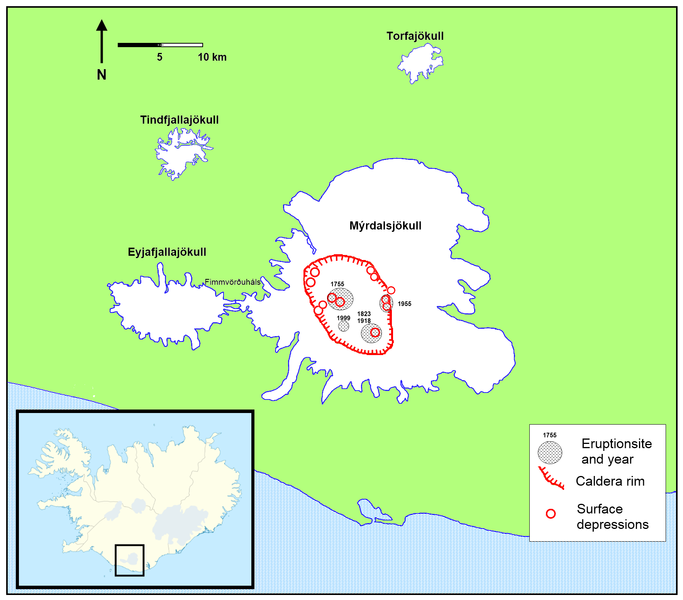
English: Partly enlarged section: shows the area of Mýrdalsjökull-glacier with estimated location of the caldera of Katla-volcano. Location is based on this study Pdf |
| Date | |
| Source | Iceland location map.svg from Wikipedia Commons |
| Author | RicHard-59 |
Licensing[edit]
I, the copyright holder of this work, hereby publish it under the following licenses:
This file is licensed under the Creative Commons Attribution-Share Alike 3.0 Unported license.
- You are free:
- to share – to copy, distribute and transmit the work
- to remix – to adapt the work
- Under the following conditions:
- attribution – You must give appropriate credit, provide a link to the license, and indicate if changes were made. You may do so in any reasonable manner, but not in any way that suggests the licensor endorses you or your use.
- share alike – If you remix, transform, or build upon the material, you must distribute your contributions under the same or compatible license as the original.

|
Permission is granted to copy, distribute and/or modify this document under the terms of the GNU Free Documentation License, Version 1.2 or any later version published by the Free Software Foundation; with no Invariant Sections, no Front-Cover Texts, and no Back-Cover Texts. A copy of the license is included in the section entitled GNU Free Documentation License. |
You may select the license of your choice.
File history
Click on a date/time to view the file as it appeared at that time.
| Date/Time | Thumbnail | Dimensions | User | Comment | |
|---|---|---|---|---|---|
| current | 20:33, 30 August 2010 | | 1,769 × 1,553 (229 KB) | RicHard-59 (talk | contribs) | Added location of 1999 eruption based on image on [http://pics.livejournal.com/michaelbix/pic/0001db5b pics.livejournal.com] |
| 07:45, 29 May 2010 |  | 1,769 × 1,553 (228 KB) | RicHard-59 (talk | contribs) | The glaciers: more details; caldera rim more precise; eruption sites; surface depression-sites | |
| 08:48, 27 April 2010 |  | 724 × 500 (69 KB) | RicHard-59 (talk | contribs) | {{Information |Description={{en|1=Partly enlarged section: shows the area of Mýrdalsjökull-glacier with estimated location of the caldera of Katla-volcano. Location is based on this [http://www.raunvis.hi.is/~mtg/pdf/Jokull49_HBetal_Myrdalsjokull.pdf st |
You cannot overwrite this file.
File usage on Commons
The following 3 pages use this file:
File usage on other wikis
The following other wikis use this file:
- Usage on bn.wikipedia.org
- Usage on cs.wikipedia.org
- Usage on de.wikipedia.org
- Usage on en.wikipedia.org
- Usage on es.wikipedia.org
- Usage on fi.wikipedia.org
- Usage on hy.wikipedia.org
- Usage on is.wikipedia.org
- Usage on ky.wikipedia.org
- Usage on mk.wikipedia.org
- Usage on pl.wikipedia.org
- Usage on ro.wikipedia.org
- Usage on sl.wikipedia.org
- Usage on sv.wikipedia.org
Categories:
- Subglacial volcanoes
- Maps of Mýrdalsjökull
- Ice cauldrons of Katla
- Maps of Katla (central volcano)
- Volcanological maps of Iceland
- Calderas in Iceland
- Subglacial caldera of Katla
- Volcanism of Katla
- Volcanology in Iceland
- Volcanism of Suðurland
- Volcanoes of the Katla volcanic system
- Vents (volcanism) of the Katla volcanic system