File:MH370 SIO search through Nov 2014.svg

Original file (SVG file, nominally 512 × 393 pixels, file size: 6.65 MB)
Captions
Captions
Summary[edit]
| DescriptionMH370 SIO search through Nov 2014.svg |
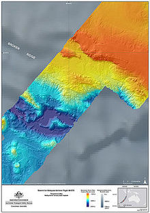
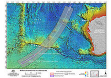
English: Map of the search areas for Malaysia Airlines Flight 370 in the Southern Indian Ocean (English).
Not shown:
中文(中国大陆):本地图展示了南印度洋海域马来西亚航空370号班机的搜寻区域。(英文)
未展示出来的有:
|
|||||
| Date | ||||||
| Source |
Own work The following sources were used for data included in the map. Locations (eg. where the search was conducted, locations of satellite debris & acoustic detections) are factual information which is not subject to copyright. Most sources are noted in the map. Main map
Towed Pinger Locator path & seafloor sonar survey location:
Background:
|
|||||
| Author | Andrew Heneen | |||||
| Permission (Reusing this file) |
I, the copyright holder of this work, hereby publish it under the following license: This file is licensed under the Creative Commons Attribution 4.0 International license.
|
|||||
| Other versions |
|
|||||
| SVG development InfoField |
|
| Annotations InfoField | This image is annotated: View the annotations at Commons |
File history
Click on a date/time to view the file as it appeared at that time.
| Date/Time | Thumbnail | Dimensions | User | Comment | |
|---|---|---|---|---|---|
| current | 09:45, 17 December 2017 |  | 512 × 393 (6.65 MB) | JoKalliauer (talk | contribs) | removed rsvg-bug (flowtext), made file valid |
| 19:02, 10 August 2015 |  | 4,796 × 3,677 (6.76 MB) | AHeneen (talk | contribs) | fix typos | |
| 20:31, 31 July 2015 |  | 4,796 × 3,677 (6.75 MB) | AHeneen (talk | contribs) | Updated to 31 July 2015, including the expanded underwater search area (announced April 2015) and years were added to dates; to accommodate these changes, some unchanged elements were moved to different positions | |
| 06:50, 13 December 2014 |  | 4,796 × 3,677 (6.75 MB) | AHeneen (talk | contribs) | 30° label was not aligned properly | |
| 06:19, 13 December 2014 |  | 4,796 × 3,677 (6.75 MB) | AHeneen (talk | contribs) | minor adjustment to legend | |
| 07:03, 9 December 2014 |  | 4,796 × 3,677 (6.74 MB) | AHeneen (talk | contribs) | Remove "Background: Natural Earth" from lower right box | |
| 06:28, 9 December 2014 |  | 4,796 × 3,677 (6.74 MB) | AHeneen (talk | contribs) | Deleted hidden layers from SVG file (file size reduced about 40%)...now hopefully PNG preview issue is fixed | |
| 06:20, 9 December 2014 |  | 4,796 × 3,677 (10.43 MB) | AHeneen (talk | contribs) | changes that will hopefully fix an issue with rendering PNG preview | |
| 05:40, 9 December 2014 |  | 4,796 × 3,677 (10.43 MB) | AHeneen (talk | contribs) | Change to a color relief background with hillshade (now uses ETOPO1 data from NASA for bathymetry & Natural Earth for Australia outline); lat/long gradients are now vectors, which will hopefully resolve issues with them disappearing in PNG preview | |
| 02:44, 8 December 2014 |  | 4,796 × 3,677 (3.98 MB) | AHeneen (talk | contribs) | Additional flight paths & some clean up / improvements |
You cannot overwrite this file.
File usage on Commons
The following 13 pages use this file:
- User:JoKalliauer
- User:JoKalliauer/Pictures
- Commons:Quality images candidates/Archives December 18 2014
- Commons:WikiProject Aviation/recent uploads/2014 December 6
- Commons:WikiProject Aviation/recent uploads/2015 August 10
- Commons:WikiProject Aviation/recent uploads/2015 July 31
- Commons:WikiProject Aviation/recent uploads/2017 December 17
- File:MH370 SIO search-en.svg
- File:MH370 SIO search-zh-s.svg
- File:MH370 SIO search.png
- File:MH370 SIO search through Nov 2014.svg
- File:MH370 TPL search and sonar survey.svg
- File:MH370 search March through October 2014.svg
File usage on other wikis
The following other wikis use this file:
- Usage on de.wikipedia.org
Metadata
This file contains additional information such as Exif metadata which may have been added by the digital camera, scanner, or software program used to create or digitize it. If the file has been modified from its original state, some details such as the timestamp may not fully reflect those of the original file. The timestamp is only as accurate as the clock in the camera, and it may be completely wrong.
| Width | 100% |
|---|---|
| Height | 100% |


