File:MINE DRAINAGE DITCH. HEADGATE IN LEFT BACKGROUND DIVERTS DRAIN WATER INTO SETTLING POND. VIEW TO EAST. - Park Utah Mining Company- Keetley Mine Complex, 1 mile East of U.S. 40 HAER UTAH,26-HEBCI.V,3-8.tif
Jump to navigation
Jump to search

Size of this JPG preview of this TIF file: 749 × 600 pixels. Other resolutions: 300 × 240 pixels | 600 × 480 pixels | 959 × 768 pixels | 1,279 × 1,024 pixels | 2,558 × 2,048 pixels | 5,000 × 4,004 pixels.
Original file (5,000 × 4,004 pixels, file size: 19.1 MB, MIME type: image/tiff)
Captions
Captions
Add a one-line explanation of what this file represents
Summary[edit]
| MINE DRAINAGE DITCH. HEADGATE IN LEFT BACKGROUND DIVERTS DRAIN WATER INTO SETTLING POND. VIEW TO EAST. - Park Utah Mining Company- Keetley Mine Complex, 1 mile East of U.S. 40 at Keetley, Heber City, Wasatch County, UT | ||||
|---|---|---|---|---|
| Title |
MINE DRAINAGE DITCH. HEADGATE IN LEFT BACKGROUND DIVERTS DRAIN WATER INTO SETTLING POND. VIEW TO EAST. - Park Utah Mining Company- Keetley Mine Complex, 1 mile East of U.S. 40 at Keetley, Heber City, Wasatch County, UT |
|||
| Description |
Ontario Mining Company |
|||
| Depicted place | Utah; Wasatch County; Heber City | |||
| Date | Documentation compiled after 1968 | |||
| Dimensions | 4 x 5 in. | |||
| Current location |
Library of Congress Prints and Photographs Division Washington, D.C. 20540 USA http://hdl.loc.gov/loc.pnp/pp.print |
|||
| Accession number |
HAER UTAH,26-HEBCI.V,3-8 |
|||
| Credit line |
|
|||
| Notes |
|
|||
| Source | https://www.loc.gov/pictures/item/ut0213.photos.158827p | |||
| Permission (Reusing this file) |
|
|||

File history
Click on a date/time to view the file as it appeared at that time.
| Date/Time | Thumbnail | Dimensions | User | Comment | |
|---|---|---|---|---|---|
| current | 01:09, 4 August 2014 | 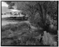 | 5,000 × 4,004 (19.1 MB) | Fæ (talk | contribs) | GWToolset: Creating mediafile for Fæ. HABS 2014-08-02 (3401:3600) |
You cannot overwrite this file.
File usage on Commons
The following page uses this file: