File:Magyarország vasúti térképe.svg
Jump to navigation
Jump to search

Size of this PNG preview of this SVG file: 800 × 503 pixels. Other resolutions: 320 × 201 pixels | 640 × 403 pixels | 1,024 × 644 pixels | 1,280 × 805 pixels | 2,560 × 1,610 pixels | 3,450 × 2,170 pixels.
Original file (SVG file, nominally 3,450 × 2,170 pixels, file size: 450 KB)
Captions
Captions
Add a one-line explanation of what this file represents
Summary[edit]
| Description |
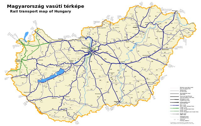
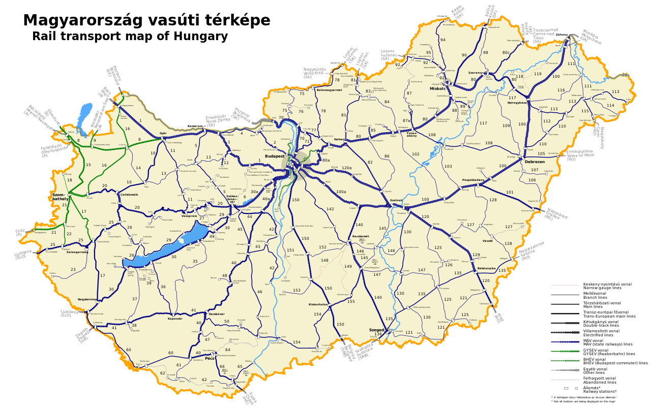
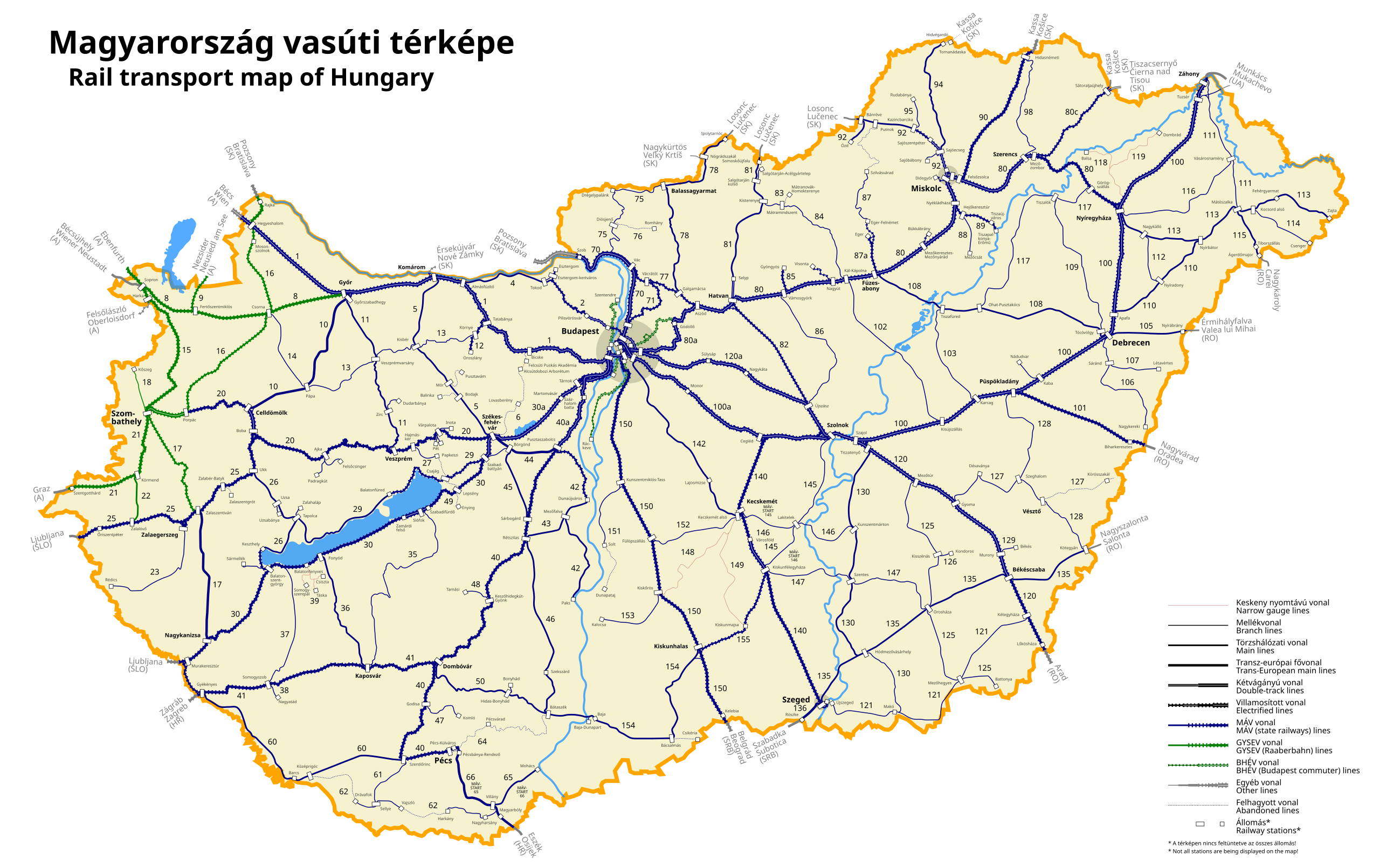
English: Rail transport map of Hungary Magyar: Magyarország vasúti térképe |
||
| Date | |||
| Source |
Own work, English: using by Magyarország vasúti árufuvarozási térképe and the database of Hungarian Rail Capacity Allocation Office (VPE) |
||
| Author | JolietJake (Hu) | ||
| Permission (Reusing this file) |
I, the copyright holder of this work, hereby publish it under the following licenses: This file is licensed under the Creative Commons Attribution-Share Alike 3.0 Unported license.
You may select the license of your choice. |

File history
Click on a date/time to view the file as it appeared at that time.
| Date/Time | Thumbnail | Dimensions | User | Comment | |
|---|---|---|---|---|---|
| current | 19:21, 12 October 2023 | | 3,450 × 2,170 (450 KB) | VT (talk | contribs) | 101-es bevillamosítva |
| 16:39, 21 January 2023 |  | 3,450 × 2,170 (450 KB) | HC Strelok (talk | contribs) | 48-as vonal korrigálva | |
| 14:08, 10 October 2021 |  | 3,450 × 2,170 (450 KB) | HC Strelok (talk | contribs) | Felhagyott vonalak frissítve, Berhidai Gyártelepek helyett Papkeszi | |
| 08:21, 10 October 2021 |  | 3,450 × 2,170 (448 KB) | HC Strelok (talk | contribs) | Angol fordítás, határon átmenő vonalak hivatalos állomásneveinek bevitele, szövegtördelés és elrendezés javítása. | |
| 22:29, 9 October 2021 |  | 3,450 × 2,170 (440 KB) | HC Strelok (talk | contribs) | Villamosítás Balatonfüredig (29) Felcsúti kisvasút (ex-6), Ágcsernyő javítva Tiszacsernyőre, üzemképtelen vonalak javítva (Mór-Pusztavám, 27-es, 48-as 49-es) | |
| 09:07, 1 May 2020 |  | 3,450 × 2,170 (438 KB) | HC Strelok (talk | contribs) | Reverted to version as of 09:04, 1 May 2020 (UTC) | |
| 09:05, 1 May 2020 |  | 3,450 × 2,170 (439 KB) | HC Strelok (talk | contribs) | Reverted to version as of 07:20, 1 May 2020 (UTC) | |
| 09:04, 1 May 2020 |  | 3,450 × 2,170 (438 KB) | HC Strelok (talk | contribs) | Budapest-Esztergom (2), ill. Mezőzombor-Sátoraljaújhely (80C) villamosítása jelölve | |
| 07:20, 1 May 2020 |  | 3,450 × 2,170 (439 KB) | Regasterios (talk | contribs) | HC Strelok módosítása áthozva a huwikiről: Fájl:Magyarország vasúti térképe 2020.svg | |
| 23:05, 20 December 2016 |  | 3,450 × 2,170 (441 KB) | D.i.l. (talk | contribs) | sorry, mégegyszer: 17-es vasútvonal északi része GYSEV által villamosítva/northern part of line 17 electrified by GYSEV |
You cannot overwrite this file.
File usage on Commons
More than 100 pages use this file. The following list shows the first 100 pages that use this file only. A full list is available.
- File:Aszód–Balassagyarmat–Ipolytarnóc-vasútvonal.svg
- File:Aszód–Vácrátót-vasútvonal.svg
- File:Bajánsenye–Zalaegerszeg–Ukk–Boba-vasútvonal.svg
- File:Balatonfenyvesi Gazdasági Vasút.svg
- File:Balatonszentgyörgy–Tapolca–Ukk-vasútvonal.svg
- File:Bicske–Székesfehérvár-vasútvonal.svg
- File:Budapest–Dombóvár–Pécs-vasútvonal.svg
- File:Budapest–Esztergom-vasútvonal.svg
- File:Budapest–Hegyeshalom–Rajka-vasútvonal.svg
- File:Budapest–Kelebia-vasútvonal.svg
- File:Budapest–Lajosmizse–Kecskemét-vasútvonal.svg
- File:Budapest–Szolnok–Békéscsaba–Lőkösháza-vasútvonal.svg
- File:Budapest–Székesfehérvár–Murakeresztúr-vasútvonal.svg
- File:Budapest–Vácrátót–Vác-vasútvonal.svg
- File:Budapest–Vác–Szob-vasútvonal.svg
- File:Bátaszék–Baja–Kiskunhalas-vasútvonal.svg
- File:Békéscsaba–Kétegyháza–Mezőhegyes–Újszeged-vasútvonal.svg
- File:Békéscsaba–Kötegyán–Vésztő–Püspökladány-vasútvonal.svg
- File:Cegléd–Szeged-vasútvonal.svg
- File:Debrecen–Füzesabony-vasútvonal.svg
- File:Debrecen–Nyírbátor–Mátészalka-vasútvonal.svg
- File:Debrecen–Nyírábrány-vasútvonal.svg
- File:Debrecen–Sáránd–Létavértes-vasútvonal.svg
- File:Debrecen–Sáránd–Nagykereki-vasútvonal.svg
- File:Debrecen–Tiszalök-vasútvonal.svg
- File:Diósjenő–Romhány-vasútvonal.svg
- File:Dombóvár–Bátaszék-vasútvonal.svg
- File:Dombóvár–Gyékényes-vasútvonal.svg
- File:Dombóvár–Komló-vasútvonal.svg
- File:Eger–Putnok-vasútvonal.svg
- File:Esztergom–Almásfüzitő-vasútvonal.svg
- File:Fertővidéki Helyiérdekű Vasút.svg
- File:Fülöpszállás–Kecskemét-vasútvonal.svg
- File:Füzesabony–Eger-vasútvonal.svg
- File:Győr–Celldömölk-vasútvonal.svg
- File:Győr–Sopron-vasútvonal.svg
- File:Győr–Veszprém-vasútvonal.svg
- File:Hatvan–Somoskőújfalu-vasútvonal.svg
- File:Hatvan–Szolnok-vasútvonal.svg
- File:Hegyeshalom–Szombathely-vasútvonal.svg
- File:Kaposvár–Fonyód-vasútvonal.svg
- File:Kaposvár–Siófok-vasútvonal.svg
- File:Karcag–Tiszafüred-vasútvonal.svg
- File:Kazincbarcika–Rudabánya-vasútvonal.svg
- File:Kecskeméti Kisvasút.svg
- File:Kecskemét–Kunszentmárton-vasútvonal.svg
- File:Keszőhidegkút-Gyönk–Tamási-vasútvonal.svg
- File:Kiskunfélegyháza–Szentes–Orosháza-vasútvonal.svg
- File:Kiskunhalas–Kiskunfélegyháza-vasútvonal.svg
- File:Kiskőrös–Kalocsa-vasútvonal.svg
- File:Kisszénás–Kondoros-vasútvonal.svg
- File:Kisterenye–Kál-Kápolna-vasútvonal.svg
- File:Kunszentmiklós-Tass–Dunapataj-vasútvonal.svg
- File:Kál-Kápolna–Kisújszállás-vasútvonal.svg
- File:Körmend–Zalalövő-vasútvonal.svg
- File:Körösnagyharsány–Vésztő–Gyoma-vasútvonal.svg
- File:Lepsény–Veszprém-vasútvonal.svg
- File:Mezőcsát–Nyékládháza-vasútvonal.svg
- File:Mezőtúr–Orosháza–Mezőhegyes-vasútvonal.svg
- File:Miskolc–Bánréve–Ózd-vasútvonal.svg
- File:Miskolc–Hidasnémeti-vasútvonal.svg
- File:Miskolc–Tornanádaska-vasútvonal.svg
- File:Murony–Békés-vasútvonal.svg
- File:Mátramindszent–Mátranovák–Homokterenye-vasútvonal.svg
- File:Mátészalka–Csenger-vasútvonal.svg
- File:Mátészalka–Nagykároly-vasútvonal.svg
- File:Mátészalka–Záhony-vasútvonal.svg
- File:Mór–Pusztavám-vasútvonal.svg
- File:Nagyatád–Somogyszob-vasútvonal.svg
- File:Nagykanizsa–Pécs-vasútvonal.svg
- File:Nagykálló–Nyíradony-vasútvonal.svg
- File:Nyíregyháza–Mátészalka–Zajta-vasútvonal.svg
- File:Nyírvidéki Kisvasút.svg
- File:Ohat-Pusztakócs–Nyíregyháza-vasútvonal.svg
- File:Pusztaszabolcs–Dunaújváros–Paks-vasútvonal.svg
- File:Pápa–Csorna-vasútvonal.svg
- File:Pécs–Bátaszék-vasútvonal.svg
- File:Pécs–Mohács-vasútvonal.svg
- File:Püspökladány–Biharkeresztes-vasútvonal.svg
- File:Rédics–Zalaegerszeg-vasútvonal.svg
- File:Sellye–Szentlőrinc-vasútvonal.svg
- File:Somogyszob–Balatonszentgyörgy-vasútvonal.svg
- File:Sopron–Szombathely-vasútvonal.svg
- File:Szeged–Békéscsaba-vasútvonal.svg
- File:Szeged–Röszke-vasútvonal.svg
- File:Szerencs–Hidasnémeti-vasútvonal.svg
- File:Szolnok–Hódmezővásárhely–Makó-vasútvonal.svg
- File:Szolnok–Kiskunfélegyháza-vasútvonal.svg
- File:Szombathely–Kőszeg-vasútvonal.svg
- File:Szombathely–Nagykanizsa-vasútvonal.svg
- File:Szombathely–Szentgotthárd-vasútvonal.svg
- File:Székesfehérvár–Komárom-vasútvonal.svg
- File:Székesfehérvár–Pusztaszabolcs-vasútvonal.svg
- File:Székesfehérvár–Szombathely-vasútvonal.svg
- File:Székesfehérvár–Tapolca-vasútvonal.svg
- File:Sárbogárd–Bátaszék-vasútvonal.svg
- File:Sárbogárd–Székesfehérvár-vasútvonal.svg
- File:Tatabánya–Oroszlány-vasútvonal.svg
- File:Tatabánya–Pápa-vasútvonal.svg
- File:Tiszapalkonya-Erőmű–Tiszaújváros–Miskolc-vasútvonal.svg
View more links to this file.
File usage on other wikis
The following other wikis use this file:
- Usage on de.wikipedia.org
- Usage on en.wikipedia.org
- Usage on hu.wikipedia.org
- Magyarország
- Vasút
- Magyarországi vasútvonalak listája
- Bátaszék–Mohács-vasútvonal
- Magyarország vasúti közlekedése
- Fájlvita:Villamosított vasútvonalak.jpg
- Wikipédia:Szócikkek felépítése (vasútvonalak)
- Szerkesztő:Hkoala/Archívum2011K
- Magyarország közlekedése
- Wikipédia:Kocsmafal (műszaki)/Archív91
- Balatoni Körvasút
- Usage on www.wikidata.org