File:Map-1579 Union of Utrecht.png
Jump to navigation
Jump to search
Size of this preview: 523 × 600 pixels. Other resolutions: 209 × 240 pixels | 599 × 687 pixels.
Original file (599 × 687 pixels, file size: 173 KB, MIME type: image/png)
Captions
Captions
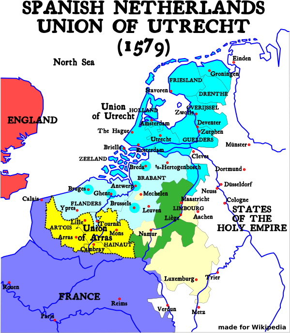
The Netherlands in 1579, indicating the Unions of Utrecht (blue) and Atrecht (yellow)

| Description |
English: Map of the Union of Utrecht in 1579 |
| Source | |
| Author | User:Moyogo |
| Other versions | Original svg file: Image:1579 Union of Utrecht.svg |

|
This historical map image could be re-created using vector graphics as an SVG file. This has several advantages; see Commons:Media for cleanup for more information. If an SVG form of this image is available, please upload it and afterwards replace this template with
{{vector version available|new image name}}.
It is recommended to name the SVG file “Map-1579 Union of Utrecht.svg”—then the template Vector version available (or Vva) does not need the new image name parameter. |
This file is licensed under the Creative Commons Attribution-Share Alike 1.0 Generic license.
- You are free:
- to share – to copy, distribute and transmit the work
- to remix – to adapt the work
- Under the following conditions:
- attribution – You must give appropriate credit, provide a link to the license, and indicate if changes were made. You may do so in any reasonable manner, but not in any way that suggests the licensor endorses you or your use.
- share alike – If you alter, transform, or build upon this work, you must distribute the resulting work under the same license as the original.
File history
Click on a date/time to view the file as it appeared at that time.
| Date/Time | Thumbnail | Dimensions | User | Comment | |
|---|---|---|---|---|---|
| current | 14:16, 9 January 2005 | | 599 × 687 (173 KB) | Moyogo (talk | contribs) | |
| 15:12, 26 December 2004 |  | 599 × 687 (173 KB) | Moyogo (talk | contribs) | language mistakes | |
| 15:09, 26 December 2004 |  | 599 × 687 (178 KB) | Moyogo (talk | contribs) | Brussels, Antwerp and Bredao in the Union of Utrecht | |
| 03:50, 26 December 2004 |  | 520 × 596 (147 KB) | Moyogo (talk | contribs) | Calais -> France | |
| 03:30, 26 December 2004 |  | 527 × 604 (150 KB) | Moyogo (talk | contribs) | Map of the Union of Utrecht in 1579 | |
| 03:09, 26 December 2004 |  | 527 × 604 (150 KB) | Moyogo (talk | contribs) | Map of the Union of Utrecht in 1579 |
You cannot overwrite this file.
File usage on Commons
The following 4 pages use this file:
File usage on other wikis
The following other wikis use this file:
- Usage on be-tarask.wikipedia.org
- Usage on ca.wikipedia.org
- Usage on cs.wikipedia.org
- Usage on el.wikipedia.org
- Usage on en.wikipedia.org
- Usage on et.wikipedia.org
- Usage on eu.wikipedia.org
- Usage on ko.wikipedia.org
- Usage on pl.wikipedia.org
- Usage on pt.wikipedia.org
- Usage on ro.wikipedia.org
- Usage on rue.wikipedia.org
- Usage on sl.wikipedia.org
- Usage on uk.wikipedia.org
- Usage on www.wikidata.org