File:Map-Russia-Irkutsk-oblast-and-Ust-Orda-Buryatia(Areas).png
Jump to navigation
Jump to search

Size of this preview: 600 × 600 pixels. Other resolutions: 240 × 240 pixels | 480 × 480 pixels.
Original file (800 × 800 pixels, file size: 156 KB, MIME type: image/png)
Captions
Captions
Add a one-line explanation of what this file represents
| Description |
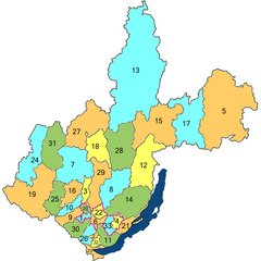
Русский: Карта Иркутской области и Усть-Ордынского Бурятского автономного округа, Российская Федерация. |
||
| Date | |||
| Source | |||
| Author | Andrey Sdobnikov | ||
| Permission (Reusing this file) |
|
File history
Click on a date/time to view the file as it appeared at that time.
| Date/Time | Thumbnail | Dimensions | User | Comment | |
|---|---|---|---|---|---|
| current | 21:54, 20 June 2009 | | 800 × 800 (156 KB) | Сдобников Андрей (talk | contribs) | {{Information |Description={{en|1=Map of Irkutsk Oblast and Ust-Orda Buryat Okrug, Russian Federation.}} {{ru|1=Карта Иркутской области и |
You cannot overwrite this file.
File usage on Commons
There are no pages that use this file.
File usage on other wikis
The following other wikis use this file:
- Usage on bg.wikipedia.org
- Usage on cs.wikipedia.org
- Usage on de.wikipedia.org
- Usage on en.wikipedia.org
- Usage on fr.wikipedia.org
- Usage on kk.wikipedia.org
- Usage on ko.wikipedia.org
- Usage on ru.wikipedia.org
- Usage on ru.wikimedia.org
- Usage on sr.wikipedia.org
.png&oldid=567840118)