File:Map2013.jpg
Jump to navigation
Jump to search

Size of this preview: 800 × 549 pixels. Other resolutions: 320 × 220 pixels | 640 × 439 pixels | 1,094 × 751 pixels.
Original file (1,094 × 751 pixels, file size: 221 KB, MIME type: image/jpeg)
Captions
Captions
Add a one-line explanation of what this file represents
Summary[edit]
| Description |
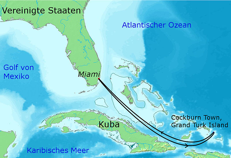
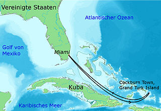
English: Map of the Caribbean showing the route of the Majesty of the Seas at the 70000 Tons of Metal Festival 2013 |
| Date | |
| Source |
This file was derived from: |
| Author |
|


| This is a retouched picture, which means that it has been digitally altered from its original version. Modifications: composed and route added. The original can be viewed here: Topographic30deg N30W60.png:
|
Licensing[edit]
This file is licensed under the Creative Commons Attribution-Share Alike 3.0 Unported license.
- You are free:
- to share – to copy, distribute and transmit the work
- to remix – to adapt the work
- Under the following conditions:
- attribution – You must give appropriate credit, provide a link to the license, and indicate if changes were made. You may do so in any reasonable manner, but not in any way that suggests the licensor endorses you or your use.
- share alike – If you remix, transform, or build upon the material, you must distribute your contributions under the same or compatible license as the original.
Original upload log[edit]
This image is a derivative work of the following images:
- File:Topographic30deg_N0W60.png licensed with PD-Demis
- 2005-05-26T17:28:09Z Koba-chan 1800x1800 (926487 Bytes) ---- Map created from [http://www2.demis.nl/mapserver/mapper.asp DEMIS Mapserver], which are public domain. [[User:Koba-chan|Koba-chan]] {{GFDL}} [[Category:Topographic maps]] [[Category:Earth]]
- File:Topographic30deg_N0W90.png licensed with Cc-by-sa-3.0-migrated, GFDL
- 2005-05-26T17:23:38Z Koba-chan 1800x1800 (903228 Bytes) ---- Map created from [http://www2.demis.nl/mapserver/mapper.asp DEMIS Mapserver], which are public domain. [[User:Koba-chan|Koba-chan]] {{GFDL}} [[Category:Topographic maps]] [[Category:Earth]]
- File:Topographic30deg_N30W60.png licensed with Cc-by-sa-3.0-migrated, GFDL
- 2005-05-26T17:42:25Z Koba-chan 1800x1800 (885775 Bytes) ---- Map created from [http://www2.demis.nl/mapserver/mapper.asp DEMIS Mapserver], which are public domain. [[User:Koba-chan|Koba-chan]] {{GFDL}} [[Category:Topographic maps]] [[Category:Earth]]
File history
Click on a date/time to view the file as it appeared at that time.
| Date/Time | Thumbnail | Dimensions | User | Comment | |
|---|---|---|---|---|---|
| current | 15:59, 15 May 2013 | | 1,094 × 751 (221 KB) | Trollhead (talk | contribs) | == {{int:filedesc}} == {{Information |Description=== {{en|1=Map of the Caribbean showing the route of the Majesty of the Seas at the 70000 Tons of Metal Festival 2013}} |Source={{Derived from|Topographic30deg_N0W60.png|Topographic30deg_N0W90.png|Topogr... |
You cannot overwrite this file.
File usage on Commons
There are no pages that use this file.
File usage on other wikis
The following other wikis use this file:
- Usage on de.wikipedia.org
- Usage on en.wikipedia.org
- Usage on fr.wikipedia.org
- Usage on hu.wikipedia.org
- Usage on no.wikipedia.org