File:Map Byzantine Empire 1076-fr.jpg
Jump to navigation
Jump to search

Size of this preview: 800 × 450 pixels. Other resolutions: 320 × 180 pixels | 640 × 360 pixels | 1,024 × 576 pixels | 1,280 × 720 pixels | 2,560 × 1,440 pixels | 5,333 × 3,000 pixels.
Original file (5,333 × 3,000 pixels, file size: 550 KB, MIME type: image/jpeg)
Captions
Captions
Add a one-line explanation of what this file represents
Summary[edit]
| Description |
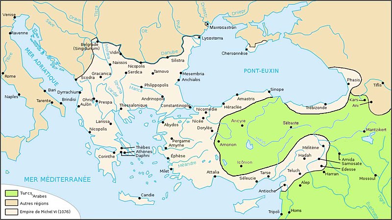
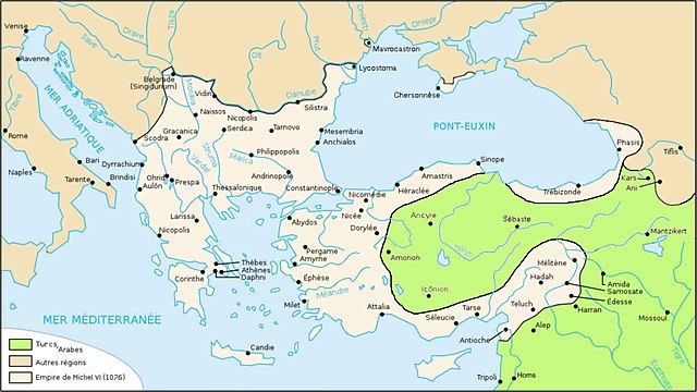
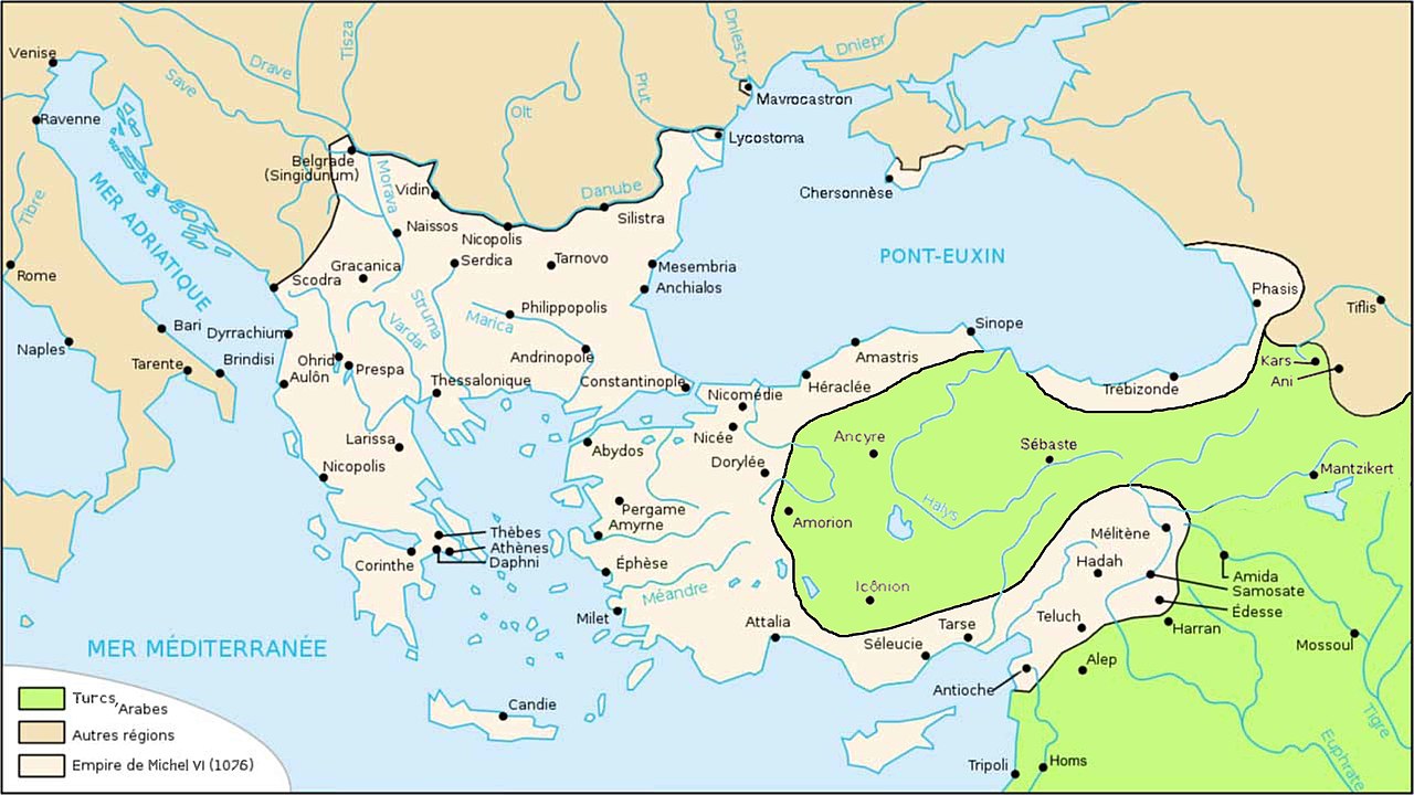
English: Uploaded to replace "Map Byzantine Empire 1076-fr.svg", which is wrong because since all historic atlases and also John Haldon : Warfare, State And Society In The Byzantine World 565-1204 (Routledge 1999) ISBN 1-85728-494-1, Maps IV et follow., & Piers Paul Read, "The Templars", London, Phoenix Press, Orion Publ. Group, 2001, ISBN 978-0-7538-1087-3, pp. 65-66, & Claude Mutafian and Éric van Lauwe, Atlas historique de l'Arménie, ed. Autrement, Paris, 2001, ISSN 2-7467-0100-6, pp. 52-53, after Mantzikert (1071), under Michael VI Dukas, the Turks annexed central Anatolia (not the west, not the coast and not Cilicia, later conquested). Français : Téléchargée pour remplacer "Map Byzantine Empire 1076-fr.svg", fausse car, d'après tous les atlas historiques et d'après John Haldon : Warfare, State And Society In The Byzantine World 565-1204 (Routledge 1999) ISBN 1-85728-494-1, Maps IV et suiv., Piers Paul Read, "The Templars", London, Phoenix Press, Orion Publ. Group, 2001, ISBN 978-0-7538-1087-3, pp. 65-66, et Claude Mutafian & Éric van Lauwe, Atlas historique de l'Arménie, ed. Autrement, Paris, 2001, ISSN 2-7467-0100-6, pp. 52-53, après Mantzikert (1071), sous Michel VI Doukas, les Seldjoukides ont annexé l'Anatolie centrale (pas l'occidentale, pas les côtes, pas le Pont et pas la Cilicie, qui viendront plus tard). |
| Date | |
| Source | Own work |
| Author | Spiridon Ion Cepleanu |
| Other versions |
[]
|


|
This map image could be re-created using vector graphics as an SVG file. This has several advantages; see Commons:Media for cleanup for more information. If an SVG form of this image is available, please upload it and afterwards replace this template with
{{vector version available|new image name}}.
It is recommended to name the SVG file “Map Byzantine Empire 1076-fr.svg”—then the template Vector version available (or Vva) does not need the new image name parameter. |


Licensing[edit]
I, the copyright holder of this work, hereby publish it under the following license:
This file is licensed under the Creative Commons Attribution-Share Alike 3.0 Unported license.
- You are free:
- to share – to copy, distribute and transmit the work
- to remix – to adapt the work
- Under the following conditions:
- attribution – You must give appropriate credit, provide a link to the license, and indicate if changes were made. You may do so in any reasonable manner, but not in any way that suggests the licensor endorses you or your use.
- share alike – If you remix, transform, or build upon the material, you must distribute your contributions under the same or compatible license as the original.
File history
Click on a date/time to view the file as it appeared at that time.
| Date/Time | Thumbnail | Dimensions | User | Comment | |
|---|---|---|---|---|---|
| current | 22:13, 30 April 2012 | | 5,333 × 3,000 (550 KB) | Spiridon Ion Cepleanu (talk | contribs) |
You cannot overwrite this file.
File usage on Commons
The following 8 pages use this file:
File usage on other wikis
The following other wikis use this file:
- Usage on el.wikipedia.org
- Usage on et.wikipedia.org
- Usage on fr.wikipedia.org
- Usage on it.wikipedia.org
- Usage on lt.wikipedia.org