File:Map Houston.jpg
Jump to navigation
Jump to search
Size of this preview: 611 × 599 pixels. Other resolutions: 245 × 240 pixels | 489 × 480 pixels | 783 × 768 pixels | 1,044 × 1,024 pixels | 1,988 × 1,950 pixels.
Original file (1,988 × 1,950 pixels, file size: 1.17 MB, MIME type: image/jpeg)
Captions
Captions
Add a one-line explanation of what this file represents
Summary[edit]
| Description |
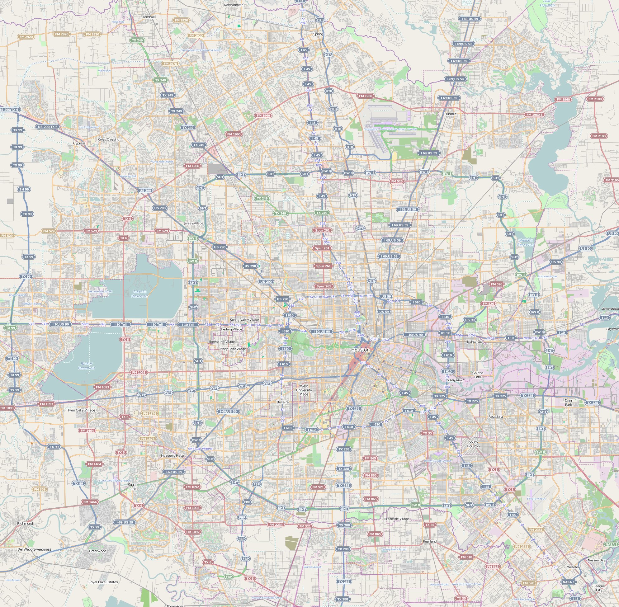
This map of Houston was created from OpenStreetMap project data, collected by the community. This map may be incomplete, and may contain errors. Don't rely solely on it for navigation. |
|||||||||
| Date | (see file history) | |||||||||
| Source | openstreetmap.org | |||||||||
| Creator |
OpenStreetMap contributors |
|||||||||
| Permission (Reusing this file) |
OpenStreetMap data and maps are licensed under the Creative Commons Attribution-ShareAlike 2.0 license (CC-BY-SA 2.0). This file is licensed under the Creative Commons Attribution-Share Alike 2.0 Generic license.
|
|||||||||
| Geotemporal data | ||||||||||
| Bounding box |
|
|||||||||
| Georeferencing | If inappropriate please set warp_status = skip to hide. | |||||||||
Licensing[edit]
This file is licensed under the Creative Commons Attribution-Share Alike 3.0 Unported license.
- You are free:
- to share – to copy, distribute and transmit the work
- to remix – to adapt the work
- Under the following conditions:
- attribution – You must give appropriate credit, provide a link to the license, and indicate if changes were made. You may do so in any reasonable manner, but not in any way that suggests the licensor endorses you or your use.
- share alike – If you remix, transform, or build upon the material, you must distribute your contributions under the same or compatible license as the original.
File history
Click on a date/time to view the file as it appeared at that time.
| Date/Time | Thumbnail | Dimensions | User | Comment | |
|---|---|---|---|---|---|
| current | 14:36, 28 August 2014 | | 1,988 × 1,950 (1.17 MB) | XIIIfromTOKYO (talk | contribs) | User created page with UploadWizard |
You cannot overwrite this file.
File usage on Commons
There are no pages that use this file.
File usage on other wikis
The following other wikis use this file:
- Usage on fr.wikipedia.org
- Aéroport intercontinental George-Bush de Houston
- Université Rice
- NRG Astrodome
- NRG Stadium
- Minute Maid Park
- Robertson Stadium
- Lakewood Church Central Campus
- Hermann Park
- Musée des sciences naturelles de Houston
- Memorial Park de Houston
- Houston Galleria
- Université de Houston
- Chapelle Rothko
- Four Leaf Towers
- 1500 Louisiana Street
- One Park Place
- 717 Texas
- The Spires
- JPMorgan Chase Building
- 2727 Kirby
- Downtown Houston
- Shell Energy Stadium
- Consulat général de France à Houston
- Modèle:Géolocalisation/Houston
- TDECU Stadium
- Module:Carte/données/houston
- Kinder High School for the Performing and Visual Arts
- Mosaic (gratte-ciel)
- Tournoi de tennis US Clay Court (ATP 2017)
- Tournoi de tennis US Clay Court (ATP 2018)
- Tournoi de tennis US Clay Court (ATP 2019)
- Cocathédrale du Sacré-Cœur de Houston
- SaberCats Stadium
- Tournoi de tennis US Clay Court (ATP 2022)
- Tournoi de tennis US Clay Court (ATP 2023)
- Tournoi de tennis US Clay Court (ATP 2024)
- Usage on ja.wikipedia.org
- Usage on lv.wikipedia.org