File:Map Pinus pinea.png
Jump to navigation
Jump to search

Size of this preview: 800 × 450 pixels. Other resolutions: 320 × 180 pixels | 840 × 473 pixels.
Original file (840 × 473 pixels, file size: 178 KB, MIME type: image/png)
Captions
Captions
Add a one-line explanation of what this file represents
Summary[edit]
| Description |
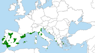
English: Stone pine (Pinus Pinea) range Italiano: Areale del pino domestico (Pinus pinea) |
| Date | (UTC) |
| Source |
|
| Author |
|
| Other versions |
|


Licensing[edit]
I, the copyright holder of this work, hereby publish it under the following licenses:
| This file is licensed under the Creative Commons Attribution-Share Alike 3.0 Unported license. | ||
| ||
| This licensing tag was added to this file as part of the GFDL licensing update. |

|
Permission is granted to copy, distribute and/or modify this document under the terms of the GNU Free Documentation License, Version 1.2 or any later version published by the Free Software Foundation; with no Invariant Sections, no Front-Cover Texts, and no Back-Cover Texts. A copy of the license is included in the section entitled GNU Free Documentation License. |
You may select the license of your choice.
Original upload log[edit]
This image is a derivative work of the following images:
- File:Blank_Map_of_Europe_-w_boundaries.svg licensed with Cc-by-sa-3.0-migrated, GFDL
- 2008-06-19T01:33:53Z Roke 2045x1720 (724499 Bytes) more accurate version derived from [[:Image:Location European nation states.svg]] using same colours
- 2006-09-25T23:00:04Z Madman2001 0x0 (224972 Bytes) A blank map of Europe using Wikipedia standard colors in SVG format, based on [[:Image:BlankMap-Europe-v5.png]]. Note that the borders represent a second object "grouped" with the outline of Europe.
Uploaded with derivativeFX
File history
Click on a date/time to view the file as it appeared at that time.
| Date/Time | Thumbnail | Dimensions | User | Comment | |
|---|---|---|---|---|---|
| current | 00:34, 15 December 2012 | | 840 × 473 (178 KB) | Carnby (talk | contribs) | == {{int:filedesc}} == {{Information |Description=''Pinus Pinea'' range |Source=Oleg Polunin Martin Walters A Guide to the Vegatation of Britain and Europe Oxford University Press, 1985 p. 115 {{Derived from|Blank_Map_of_Europe_-w_boundaries.svg|displa... |
You cannot overwrite this file.
File usage on Commons
The following 3 pages use this file:
File usage on other wikis
The following other wikis use this file:
- Usage on fr.wikipedia.org