File:Saint Kitts and Nevis, administrative divisions - mk - monochrome.svg
(Redirected from File:Map of Saint Kitts and Nevis - mk.svg)

Size of this PNG preview of this SVG file: 648 × 600 pixels. Other resolutions: 259 × 240 pixels | 519 × 480 pixels | 830 × 768 pixels | 1,106 × 1,024 pixels | 2,213 × 2,048 pixels | 1,264 × 1,170 pixels.
Original file (SVG file, nominally 1,264 × 1,170 pixels, file size: 183 KB)
Captions
Captions
Add a one-line explanation of what this file represents
Summary[edit]
| Description |
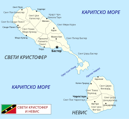
Македонски: Карта на Свети Кристофер и Невис на македонски.
English: Map of St. Kitts and Nevis in Macedonian. |
| Date | |
| Source | Own work, based on this and this map. |
| Author | labels: MacedonianBoy, map: Carport |
| Other versions | English version |
Licensing[edit]
I, the copyright holder of this work, hereby publish it under the following license:
This file is licensed under the Creative Commons Attribution-Share Alike 3.0 Unported license.
- You are free:
- to share – to copy, distribute and transmit the work
- to remix – to adapt the work
- Under the following conditions:
- attribution – You must give appropriate credit, provide a link to the license, and indicate if changes were made. You may do so in any reasonable manner, but not in any way that suggests the licensor endorses you or your use.
- share alike – If you remix, transform, or build upon the material, you must distribute your contributions under the same or compatible license as the original.
File history
Click on a date/time to view the file as it appeared at that time.
| Date/Time | Thumbnail | Dimensions | User | Comment | |
|---|---|---|---|---|---|
| current | 11:28, 16 July 2012 | | 1,264 × 1,170 (183 KB) | MacedonianBoy (talk | contribs) | с |
| 11:21, 16 July 2012 |  | 1,264 × 1,170 (182 KB) | MacedonianBoy (talk | contribs) |
You cannot overwrite this file.
File usage on Commons
The following 5 pages use this file:
File usage on other wikis
The following other wikis use this file:
Categories:
- CC-BY-SA-3.0
- SVG labeled maps of administrative divisions of countries of North America (location map scheme) (monochrome scheme)
- SVG labeled maps of administrative divisions of countries of North America (location map scheme) (macedonian)
- SVG labeled maps of administrative divisions of Saint Kitts and Nevis (location map scheme)