File:Map of a Journey to Musardu, the Capital of the Western Mandingoes WDL447.png
Jump to navigation
Jump to search

Size of this preview: 536 × 600 pixels. Other resolutions: 214 × 240 pixels | 429 × 480 pixels | 686 × 768 pixels | 1,024 × 1,146 pixels.
Original file (1,024 × 1,146 pixels, file size: 2.03 MB, MIME type: image/png)
Captions
Captions
Add a one-line explanation of what this file represents
Summary[edit]
| Author |
Русский: Андерсон, Бенджамин Д. К. (Родился в 1834 г.)
Français : Anderson, Benjamin J. K. (Né en 1834)
English: Anderson, Benjamin J. K. (Born 1834)
中文:安德森, 本杰明J. K. (生于 1834 年)
Português: Anderson, Benjamin J. K. (Nasceu em 1834)
العربية: أندرسون, بينجامين ج.
ك. (ولد 1834)
Español: Anderson, Benjamin J. K. (Nació en 1834) |
| Title |
Русский: Карта путешествия в Мусарду, столицу западного Мандинго
Français : Carte d'un voyage à Musardu, la capitale des Mandingues de l'Ouest
English: Map of a Journey to Musardu, the Capital of the Western Mandingoes
中文:穆沙都旅游地图,西部曼丁哥人首都
Português: Mapa de uma viagem para Musardu, a Capital dos Mandingos Ocidentais
العربية: خريطة رحلة إلى موساردو، عاصمة ماندينغوز الغربية
Español: Mapa de un viaje a Musardu, la capital de los Mandingos occidentales |
| Description |
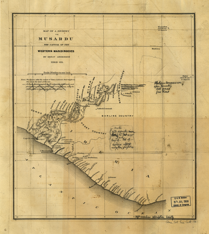
Русский: В 1868 г. президент Республики Либерия Дэниел Бэшиел Уорнер направил Бенджамина Дж. К. Андерсона, правительственного чиновника Либерии, во внутренние территории страны для ведения переговоров с королем Мусардо. Целью Уорнера было укрепить связи с народами внутренних территорий и попытаться сблизить их в экономическом и культурном отношении с прибрежными колониями, основанными иммигрантами из США. Андерсон совершил путешествие по густым лесам Либерии, чтобы собрать исчерпывающие сведения о народах, традициях и природных ресурсах этой местности. На основании официального отчета о его путешествии правительство Либерии предприняло попытку установить ограниченный контроль над регионом, исследованным Андерсоном. На этой карте из коллекции, переданной Библиотеке Конгресса Американским обществом колонизации, показан маршрут Андерсона. В 1874 году Андерсон организовал вторую экспедицию по внутренним землям Либерии.
Открытия и исследования; Район реки Сент-Пол (Либерия) Français : En 1868, le Président de la République du Libéria Daniel Bashiel Warner envoya Benjamin JK Anderson, un fonctionnaire du gouvernement libérien, dans l'intérieur du pays pour négocier un traité avec le roi de Musardo. Warner avait pour objectif d'améliorer les liens avec les peuples de l'intérieur et d'essayer de les associer, économiquement et culturellement, avec les colonies côtières établies par les immigrants des États-Unis Voyageant à travers une forêt dense, Anderson prit soigneusement des notes sur les gens, les coutumes et les ressources naturelles des régions par lesquelles il passa. Sur la base de son rapport officiel au sujet de son voyage, le gouvernement libérien se déplaça pour affirmer un contrôle limité sur la région explorée par Anderson. Cette carte des années 1830 faisant partie de la collection donnée à la Bibliothèque du Congrès par la Société de Colonisation Américaine montre l'itinéraire d'Anderson. En 1874, Anderson effectua une seconde expédition vers l'intérieur du Libéria.
Découverte et exploration; Région du fleuve Saint-Paul (Libéria) English: In 1868, President Daniel Bashiel Warner of the Republic of Liberia sent Benjamin J.K. Anderson, a Liberian government official, into the interior of the country to negotiate a treaty with the King of Musardo. Warner’s objective was to improve ties with the peoples of the interior and to try to associate them, economically and culturally, with the coastal colonies established by immigrants from the United States. Traveling through dense forest, Anderson made careful notes about the people, customs, and natural resources of the areas through which he passed. On the basis of his official report about his journey, the Liberian government moved to assert limited control over the region that Anderson had explored. This map, part of the collection given to the Library of Congress by the American Colonization Society, shows Anderson’s route. In 1874, Anderson made a second expedition to the Liberian interior.
Discovery and exploration; Saint Paul River Region (Liberia) 中文:1868 年,利比里亚共和国总统丹尼尔·贝夏·华纳派遣利比里亚政府官员本杰明·J·K· 安德森,深入王国内陆,与国王穆萨多谈判一项条约。 华纳的初衷是改善与该国内陆人民的联系,试图从经济上与文化上将他们与美国移民建立的沿海殖民地建立联系。 穿过茂密的森林,安德森对他所到之处的人民、习俗以及自然资源进行了详细的记录。 根据他的正式旅程报告,利比里亚政府逐渐宣称对安德森探险过的地区进行有限的控制。 这幅地图,属于美国殖民协会向美国国会图书馆捐献的作品集的一部分,描述了安德森的探险路线。 1874 年,安德森再次深入利比里亚内陆调查。
发现与探索; 圣保罗河地区(利比里亚) Português: Em 1868, Daniel Bashiel Warner presidente da República da Libéria enviou Benjamin J. K. Anderson, um oficial do governo liberiano, para o interior do país para negociar um tratado com o rei de Musardo. O objetivo de Warner era melhorar os laços com os povos do interior e tentar associá-los, economica e culturalmente, com as colônias costeiras, estabelecidas pelos imigrantes dos Estados Unidos. Viajando através da densa floresta, Anderson tratou de redigir notas cuidadosas sobre o povo, costumes e os recursos naturais das áreas pelas quais passou. Tendo como base seu relato oficial sobre sua jornada, o governo da Libéria agiu para tomar controle limitado da região que Anderson havia explorado. Este mapa, parte da coleção doada à Biblioteca do Congresso pela Sociedade Americana de Colonização, mostra a rota de Anderson. Em 1874, Anderson fez uma segunda expedição ao interior da Libéria.
Descoberta e exploração; Região do Rio São Paulo (Libéria) العربية: في عام 1888، أرسل دانييل باشيل وارنر رئيس جمهورية ليبيريا بنجامين ج.ك. أندرسون، وهو مسؤول في الحكومة الليبيرية، إلى المناطق الداخلية من البلاد للتفاوض على معاهدة مع ملك موسادرو. وكان هدف وارنر تحسين العلاقات مع سكان المناطق الداخلية ومحاولة ربطهم، اقتصاديا وثقافيا، مع المستعمرات الساحلية التي أنشأها المهاجرون من الولايات المتحدة. سار أندرسون عبر الغابات الكثيفة، ودون ملاحظات دقيقة عن الناس والعادات والموارد الطبيعية في المناطق التي مر بها. بناءً على تقريره الرسمي عن رحلته، تحركت الحكومة الليبيرية لفرض سيطرة محدودة على المنطقة التي استكشافها اندرسون. تظهرهذه الخريطة، وهي جزء من المجموعة التي أعطتها جمعية الاستيطان الأمريكية لمكتبة الكونغرس، المسار الذي سلكه اندرسون. وفي عام 1874، قام اندرسون ببعثة ثانية إلى ليبريا الداخلية.
الاكتشاف والاستكشاف; منطقة نهر سانت بول (ليبيريا) Español: En 1868, el presidente de la República de Liberia, Daniel Bashiel Warner, envió a Benjamin J.K. Anderson, un oficial del gobierno de Liberia, al interior del país para negociar un tratado con el rey de Musardo. El objetivo de Warner era mejorar los vínculos entre los pueblos del interior e intentar asociarlos, económica y culturalmente, con las colonias costeras establecidas por los inmigrantes de los Estados Unidos. En sus viajes a través de los densos bosques, Anderson tomó notas detalladas acerca de las gentes, las costumbres y los recursos naturales de las zonas por las que pasaba. Basándose en el informe oficial de sus viajes, el gobierno de Liberia se trasladó para mantener un control limitado sobre la región que Anderson había explorado. Este mapa, parte de la colección donada a la Biblioteca del Congreso por la Sociedad Americana de Colonización, muestra la ruta de Anderson. En 1874, Anderson llevó a cabo una segunda expedición al interior de Liberia.
Descubrimiento y exploración; Región del Río San Pablo (Liberia) |
| Date | 1869 |
| Medium |
Русский: Карты
Français : Cartes
English: Maps
中文:地图
Português: Mapas
العربية: خرائط
Español: Mapas |
| Dimensions |
English: 1 engraved map ; 37 x 32 centimeters |
| Collection |
Русский: Библиотека Конгресса
Français : Bibliothèque du Congrès
English: Library of Congress
中文:国会图书馆
Português: Biblioteca do Congresso
العربية: مكتبة الكونغرس
Español: Biblioteca del Congreso |
| Current location |
Русский: Коллекция карт Американского общества колонизации
Français : Collection des Cartes de la Société de colonisation américaine
English: American Colonization Society Map Collection
中文:美国殖民协会地图集
Português: Coleção de Mapas da Sociedade de Colonização Americana
العربية: مجموعة خرائط جمعية إنشاء المستعمرات الأمريكية
Español: Colección de mapas de la Sociedad de Colonización Americana |
| Place of creation |
Русский: Либерия
Français : Libéria
English: Liberia
中文:利比里亚
Português: Libéria
العربية: ليبيريا
Español: Liberia |
| Notes |
Original language title: Map of a Journey to Musardu, the Capital of the Western Mandingoes / by Benj'n Anderson, 1868-69 Русский: Масштаб 1:1 900 800
Français : Échelle 1:1 900 800
English: Scale 1:1,900,800
中文:比例尺:1:1,900,800
Português: Escala 1:1.900.800
العربية: المقياس نحو 1:1،900،000
Español: Escala 1:1.900.800 |
| References | http://hdl.loc.gov/loc.wdl/dlc.447 |
| Source/Photographer |
|
Licensing[edit]
|
This is a faithful photographic reproduction of a two-dimensional, public domain work of art. The work of art itself is in the public domain for the following reason:
The official position taken by the Wikimedia Foundation is that "faithful reproductions of two-dimensional public domain works of art are public domain".
This photographic reproduction is therefore also considered to be in the public domain in the United States. In other jurisdictions, re-use of this content may be restricted; see Reuse of PD-Art photographs for details. | ||||
File history
Click on a date/time to view the file as it appeared at that time.
| Date/Time | Thumbnail | Dimensions | User | Comment | |
|---|---|---|---|---|---|
| current | 17:26, 11 March 2014 | | 1,024 × 1,146 (2.03 MB) | Fæ (talk | contribs) | =={{int:filedesc}}== {{Artwork |artist = |author ={{ru|1=Андерсон, Бенджамин Д. К. (Родился в 1834 г.)}} {{fr|1=Anderson, Benjamin J. K. (Né en 1834)}} {{en|1=Anderson, Benjamin J. K. (Born 1834)}} {{zh|1=安德森, 本杰... |
You cannot overwrite this file.
File usage on Commons
The following page uses this file: