File:Mapka miedzymorza.png
Jump to navigation
Jump to search
No higher resolution available.
Mapka_miedzymorza.png (250 × 170 pixels, file size: 8 KB, MIME type: image/png)
Captions
Captions
Add a one-line explanation of what this file represents

|
This proposed entity map image could be re-created using vector graphics as an SVG file. This has several advantages; see Commons:Media for cleanup for more information. If an SVG form of this image is available, please upload it and afterwards replace this template with
{{vector version available|new image name}}.
It is recommended to name the SVG file “Mapka miedzymorza.svg”—then the template Vector version available (or Vva) does not need the new image name parameter. |
| Description |
Беларуская (тарашкевіца): Мапа плянаванай канфэдэрацыі. Сьветлым колерам адзначаны тэрыторыі Беларусі і Ўкраіны, якія ўвайшлі ў Савецкую дзяржаву пасьля 1921.
Čeština: Mapu s vyznačením území, která by zahrnovala na Międzymorze federace. Světlejší zelená značí ukrajinské a běloruské území ovládané Sovětským svazem po roce 1921.
Deutsch: Karte zeigt die Gebiete, die die Międzymorze Föderation umfassen würde. Hellgrün bezeichnet ukrainischen und weißrussischen Gebiete von der Sowjetunion nach 1921 regiert.
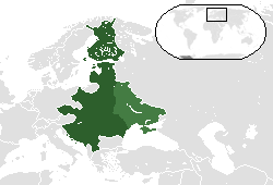
English: Map showing the territories that would comprise the Międzymorze federation. Lighter green denotes Ukrainian and Belarusian territories controlled by the Soviet Union after 1921.
Español: Mapa que muestra los territorios que componen la federación Międzymorze. De color verde claro indica territorios de Ucrania y Bielorrusia controladas por la Unión Soviética después de 1921.
Hrvatski: Karta pokazuje područja koja će obuhvaćaju Międzymorze federaciju. Upaljač zelena označava ukrajinski i bjeloruski područja kontrolom Sovjetskog Saveza nakon 1921.
Italiano: Cartina con i territori che compongono la federazione Międzymorze. Accendino verde denota territori ucraini e bielorussi controllati dall'Unione Sovietica dopo il 1921.
Lietuvių: Žemėlapis rodo teritorijas, kad būtų sukaupta Międzymorze federaciją. Žiebtuvėlis žalia žymi Ukrainos ir Baltarusijos teritorijas, kontroliuojamas Sovietų Sąjungos po 1921 m.
Polski: Mapa pokazująca terytoria, które składają się na Międzymorze federacji. Lżejszy zielony oznacza Ukrainy i Białorusi terytoria kontrolowane przez ZSRR po 1921 roku.
Русский: Карта с указанием территорий, которые должны были войти в Междуморье. Светло-зеленый показывает украинские и белорусские территории, которые попали под контроль Советского Союза после 1921 года.
Slovenčina: Mapu s vyznačením územia, ktorá by zahŕňala na Międzymorze federácie. Svetlejšie zelená značí ukrajinskej a bieloruskej územie ovládané Sovietskym zväzom po roku 1921.
Українська: Карта з позначеною територією, яка мала увійти до Міжмор’я. Світло-зелений колір показує українські та білоруські території, які потрапили під контроль Радянського Союзу після 1921 року. |
| Date | Uploaded to pl wiki on 6 April 2007. |
| Source | Uploaded to pl wiki by creator. |
| Author | Albertus |
| Other versions |
 |
I, the copyright holder of this work, hereby publish it under the following licenses:

|
Permission is granted to copy, distribute and/or modify this document under the terms of the GNU Free Documentation License, Version 1.2 or any later version published by the Free Software Foundation; with no Invariant Sections, no Front-Cover Texts, and no Back-Cover Texts. A copy of the license is included in the section entitled GNU Free Documentation License. |
This file is licensed under the Creative Commons Attribution-Share Alike 3.0 Unported, 2.5 Generic, 2.0 Generic and 1.0 Generic license.
- You are free:
- to share – to copy, distribute and transmit the work
- to remix – to adapt the work
- Under the following conditions:
- attribution – You must give appropriate credit, provide a link to the license, and indicate if changes were made. You may do so in any reasonable manner, but not in any way that suggests the licensor endorses you or your use.
- share alike – If you remix, transform, or build upon the material, you must distribute your contributions under the same or compatible license as the original.
You may select the license of your choice.
| Annotations | This image is annotated: View the annotations at Commons |
File history
Click on a date/time to view the file as it appeared at that time.
| Date/Time | Thumbnail | Dimensions | User | Comment | |
|---|---|---|---|---|---|
| current | 04:20, 12 May 2014 | | 250 × 170 (8 KB) | Spesh531 (talk | contribs) | italian coastline fixed and island in turkey removed |
| 04:06, 12 May 2014 |  | 250 × 170 (8 KB) | Spesh531 (talk | contribs) | fixing east prussia and lithuania borders | |
| 03:59, 12 May 2014 |  | 250 × 170 (8 KB) | Spesh531 (talk | contribs) | further south map | |
| 03:42, 12 May 2014 |  | 250 × 150 (7 KB) | Spesh531 (talk | contribs) | update | |
| 04:14, 17 July 2012 |  | 250 × 150 (5 KB) | Spesh531 (talk | contribs) | Version with all proposed countries, so +Finland, updated layout | |
| 19:15, 22 April 2007 |  | 250 × 115 (9 KB) | Piotrus (talk | contribs) | {{Information |Description=Map showing the territories that would comprise the Międzymorze federation. Lighter green denotes Ukrainian and Belarusian territories controlled by the Soviet Union after 1921. |Source=Uploaded to pl wiki by creator. |Date=Upl |
You cannot overwrite this file.
File usage on Commons
The following page uses this file:
File usage on other wikis
The following other wikis use this file:
- Usage on be-tarask.wikipedia.org
- Usage on be.wikipedia.org
- Usage on ca.wikipedia.org
- Usage on de.wikipedia.org
- Usage on el.wikipedia.org
- Usage on en.wikipedia.org
- Usage on eo.wikipedia.org
- Usage on es.wikipedia.org
- Usage on et.wikipedia.org
- Usage on hr.wikipedia.org
- Usage on hy.wikipedia.org
- Usage on id.wikipedia.org
- Usage on ja.wikipedia.org
- Usage on ka.wikipedia.org
- Usage on lv.wikipedia.org
- Usage on no.wikipedia.org
- Usage on pl.wikipedia.org
- Usage on ro.wikipedia.org
- Usage on ru.wikipedia.org
- Usage on sh.wikipedia.org
- Usage on sk.wikipedia.org
- Usage on sr.wikipedia.org
- Usage on sv.wikipedia.org
- Usage on tr.wikipedia.org
- Usage on uk.wikipedia.org
- Usage on vi.wikipedia.org
- Usage on zh.wikipedia.org