File:Midway Islands.svg
Jump to navigation
Jump to search

Size of this PNG preview of this SVG file: 365 × 392 pixels. Other resolutions: 223 × 240 pixels | 447 × 480 pixels | 715 × 768 pixels | 953 × 1,024 pixels | 1,907 × 2,048 pixels.
Original file (SVG file, nominally 365 × 392 pixels, file size: 37 KB)
Captions
Captions
Add a one-line explanation of what this file represents
| Description |
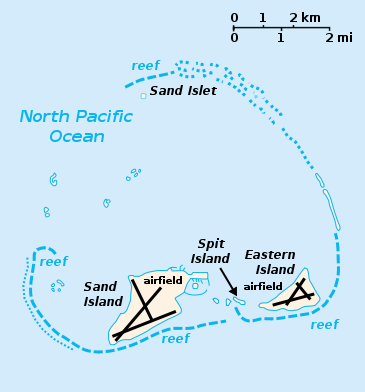
English: Midway Atoll with Sand Island, Spit Island and Eastern Island. Of the various runways on the map, all but one on Sand Island are abandoned (2009). |
||
| Date | 11/2/07 | ||
| Source | self made from CIA maps (PD) | ||
| Author | User:Indolences | ||
| Permission (Reusing this file) |
|
||
| Other versions |
Derivative works of this file: Midway Atoll map.svg |

.png)
| Open this image as an overlay in Google Earth (Google Maps, Bing) | (Help|Source) |
File history
Click on a date/time to view the file as it appeared at that time.
| Date/Time | Thumbnail | Dimensions | User | Comment | |
|---|---|---|---|---|---|
| current | 00:20, 26 March 2007 | | 365 × 392 (37 KB) | Indolences (talk | contribs) | cleaning up code |
| 00:24, 12 February 2007 |  | 365 × 392 (44 KB) | Indolences (talk | contribs) | ||
| 00:22, 12 February 2007 |  | 365 × 392 (44 KB) | Indolences (talk | contribs) | {{Information |Description= the Midway Islands |Source= self made from CIA maps (PD) |Date= 11/2/07 |Author= User:Indolences |Permission={{PD-self}} |other_versions= }} Category:Midway Island |
You cannot overwrite this file.
File usage on Commons
The following page uses this file: