File:Moers-fuda-stromkarte1.jpg
Jump to navigation
Jump to search
Size of this preview: 799 × 599 pixels. Other resolutions: 320 × 240 pixels | 640 × 480 pixels | 1,024 × 768 pixels | 1,280 × 960 pixels | 2,560 × 1,920 pixels | 2,774 × 2,081 pixels.
Original file (2,774 × 2,081 pixels, file size: 1.23 MB, MIME type: image/jpeg)
Captions
Captions
Add a one-line explanation of what this file represents
Summary[edit]
| Description |
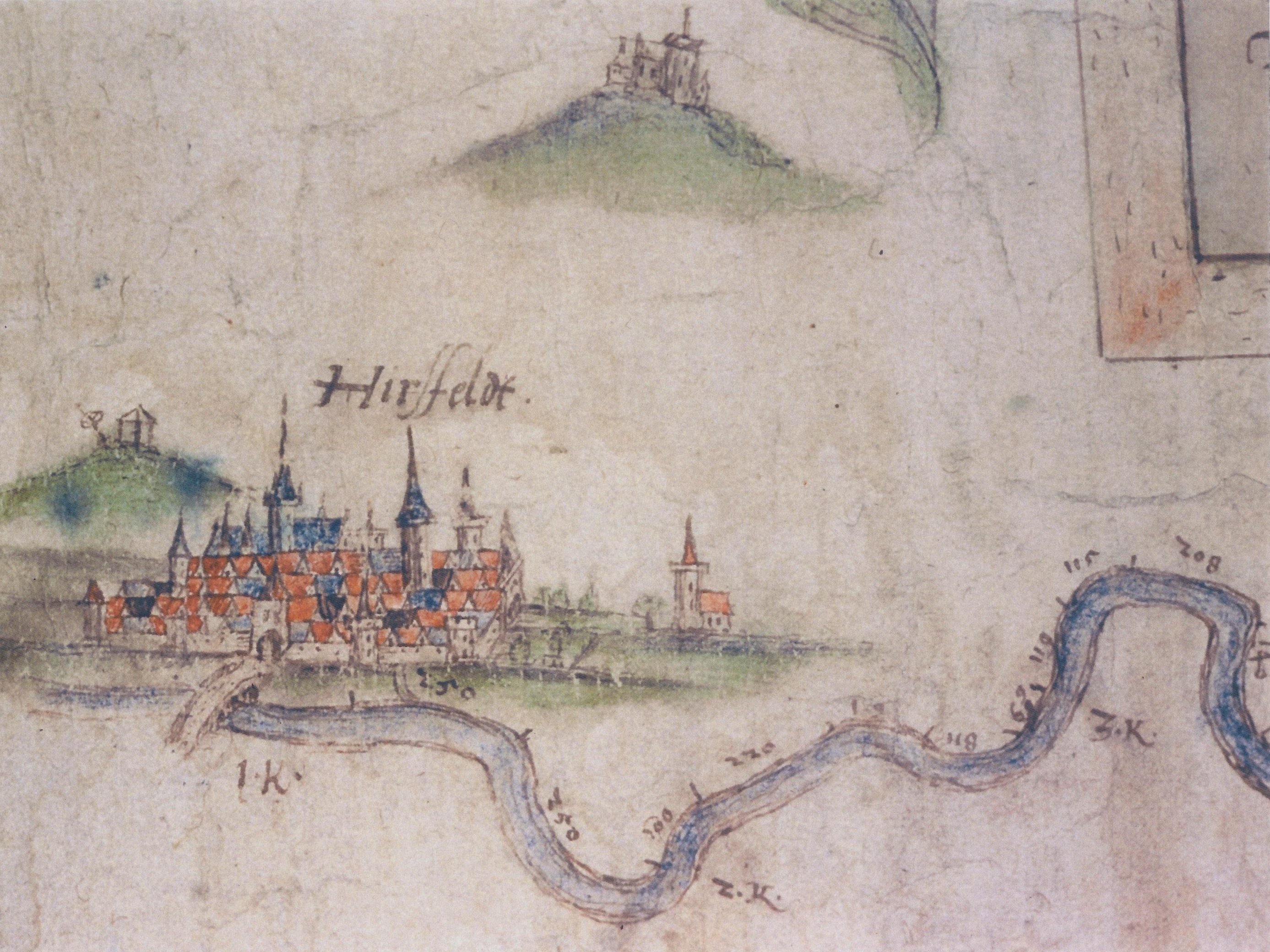
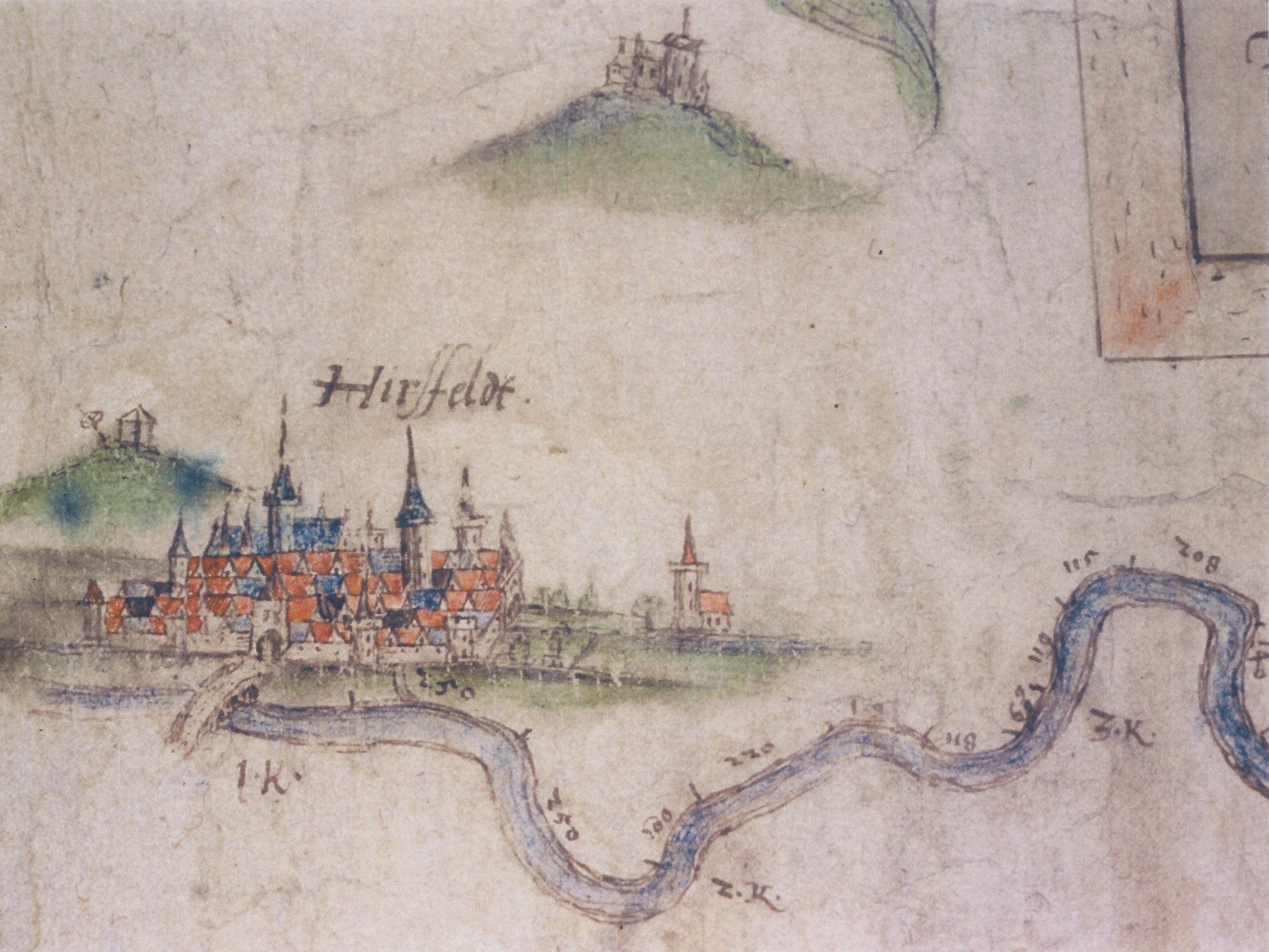
Deutsch: Erster Abschnitt aus der historischen Karte Fulda-Stromkarte von Joist Moers um 1597 angefertigt. Zu sehen ist Hersfeld mit der alten Fuldabrücke und des angedeuteten Zuflusses des Geisbaches im Vordergrund. Rechts daneben ist die auf freiem Feld, in der Fuldaaue, stehende Klauskirche eingezeichnet. Links über der Stadt ist der Galgenplatz mit Galgen und dem Richtrad angedeutet (lag auf einer Anhöhe des Tageberges, heute vermutlich in der Straße "Am Hainberg"). Rechts über der Stadt ist der Frauenberg mit dem dort befindlichen Koster angedeutet. English: First part of the historic map Fulda-Stromkarte from Joist Moers, drawn around 1597. Is's shows the town Hersfeld (today Bad Hersfeld), the old bridge over the river Fulda the church Klauskirche outside of the defensive wall from Hersfeld, the Breaking wheel and gallows, the hill Frauenberg with its monastery. |
||||
| Date | |||||
| Source | scaned | ||||
| Author | Joist Moers (ca. 1540–1625) | ||||
| Permission (Reusing this file) |
|
||||
Licensing[edit]
|
This work is in the public domain in its country of origin and other countries and areas where the copyright term is the author's life plus 100 years or fewer. | |
| This file has been identified as being free of known restrictions under copyright law, including all related and neighboring rights. | |
File history
Click on a date/time to view the file as it appeared at that time.
| Date/Time | Thumbnail | Dimensions | User | Comment | |
|---|---|---|---|---|---|
| current | 19:48, 5 July 2010 | | 2,774 × 2,081 (1.23 MB) | 2micha (talk | contribs) | {{Information |Description={{de|Erster Abschnitt aus der historischen Karte ''Fulda-Stromkarte'' von Joist Moers um 1597 angefertigt. Zu sehen ist Hersfeld mit der alten Fuldabrücke und des angedeuteten Zuflusses des Geisbaches im Vordergrund. Rechts dan |
You cannot overwrite this file.
File usage on Commons
There are no pages that use this file.
File usage on other wikis
The following other wikis use this file:
- Usage on de.wikipedia.org
- Usage on hu.wikipedia.org