File:Mogulreich Akbar.png
Jump to navigation
Jump to search
No higher resolution available.
Mogulreich_Akbar.png (432 × 347 pixels, file size: 16 KB, MIME type: image/png)
Captions
Captions
Add a one-line explanation of what this file represents
| Description |
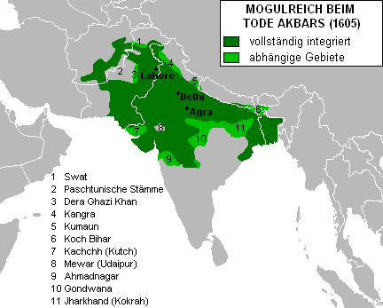
Deutsch: Ausdehnung des Mogulreiches beim Tode Akbars (1605)
English: The Mughal Empire at Akbar's death in 1605. Fully integrated territories in dark green, dependent territories in light green |
||||||||
| Date | |||||||||
| Source |
Kartenvorlage: Image:BlankMap-World-large.png Grenzen eingezeichnet nach der Karte Indien unter dem Mogulkaiser Akbar in Johnson, Gordon: Weltatlas der alten Kulturen. Indien. Christian Verlag, München 1995 |
||||||||
| Author | Jungpionier | ||||||||
| Permission (Reusing this file) |
|

File history
Click on a date/time to view the file as it appeared at that time.
| Date/Time | Thumbnail | Dimensions | User | Comment | |
|---|---|---|---|---|---|
| current | 13:14, 27 February 2012 | | 432 × 347 (16 KB) | Colomen (talk | contribs) | Reverted to version as of 14:26, 17 April 2007 English file should be moved to another place rather than overwriting the original German file! |
| 07:13, 5 November 2011 |  | 1,000 × 803 (322 KB) | Yon Man33 (talk | contribs) | Translated to English | |
| 14:26, 17 April 2007 |  | 432 × 347 (16 KB) | Jungpionier (talk | contribs) | {{Information |Description= Ausdehnung des Mogulreiches beim Tode Akbars (1605) |Source= Kartenvorlage: Image:BlankMap-World-large.png Grenzen eingezeichnet nach der Karte ''Indien unter dem Mogulkaiser Akbar'' in Johnson, Gordon: ''Weltatlas der alt |
You cannot overwrite this file.
File usage on Commons
The following 2 pages use this file:
File usage on other wikis
The following other wikis use this file:
- Usage on az.wikipedia.org
- Usage on ba.wikipedia.org
- Usage on be-tarask.wikipedia.org
- Usage on be.wikipedia.org
- Usage on bg.wikipedia.org
- Usage on ce.wikipedia.org
- Usage on de.wikipedia.org
- Usage on de.wikiversity.org
- Usage on en.wikipedia.org
- Usage on es.wikipedia.org
- Usage on et.wikipedia.org
- Usage on eu.wikipedia.org
- Usage on fa.wikipedia.org
- Usage on he.wikipedia.org
- Usage on hi.wikipedia.org
- Usage on hr.wikipedia.org
- Usage on it.wikipedia.org
- Usage on ja.wikipedia.org
- Usage on ka.wikipedia.org
- Usage on kbd.wikipedia.org
- Usage on kk.wikipedia.org
- Usage on kn.wikipedia.org
- Usage on lt.wikipedia.org
- Usage on ml.wikipedia.org
- Usage on mr.wikipedia.org
- Usage on nl.wikipedia.org
- Usage on pnb.wikipedia.org
- Usage on ps.wikipedia.org
- Usage on ru.wikipedia.org
- Usage on sh.wikipedia.org
- Usage on simple.wikipedia.org
- Usage on sq.wikipedia.org
- Usage on sw.wikipedia.org
View more global usage of this file.