File:Mount Everest location in Himalaya map-hu.svg
Jump to navigation
Jump to search

Size of this PNG preview of this SVG file: 800 × 461 pixels. Other resolutions: 320 × 184 pixels | 640 × 368 pixels | 1,024 × 589 pixels | 1,280 × 737 pixels | 2,560 × 1,474 pixels | 1,190 × 685 pixels.
Original file (SVG file, nominally 1,190 × 685 pixels, file size: 1.31 MB)
Captions
Captions
Add a one-line explanation of what this file represents
| Description |
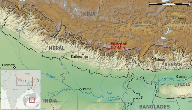
Magyar: A Himalája térképe a Mount Everest helyével English: Map of Himalaya, showing Nepal and Bhutan, and Mount Everest location. Français : Carte de l'Himalaya, montrant le Népal et le Bhoutan, et l'emplacement de l'Everest. |
| Date | (UTC) |
| Source | |
| Author |
|
| Other versions |
|


| This is a retouched picture, which means that it has been digitally altered from its original version. The original can be viewed here: Mount Everest location in Himalaya map-fr.svg:
|
I, the copyright holder of this work, hereby publish it under the following licenses:
This file is licensed under the Creative Commons Attribution-Share Alike 3.0 Unported, 2.5 Generic, 2.0 Generic and 1.0 Generic license.
- You are free:
- to share – to copy, distribute and transmit the work
- to remix – to adapt the work
- Under the following conditions:
- attribution – You must give appropriate credit, provide a link to the license, and indicate if changes were made. You may do so in any reasonable manner, but not in any way that suggests the licensor endorses you or your use.
- share alike – If you remix, transform, or build upon the material, you must distribute your contributions under the same or compatible license as the original.

|
Permission is granted to copy, distribute and/or modify this document under the terms of the GNU Free Documentation License, Version 1.2 or any later version published by the Free Software Foundation; with no Invariant Sections, no Front-Cover Texts, and no Back-Cover Texts. A copy of the license is included in the section entitled GNU Free Documentation License. |
You may select the license of your choice.
Original upload log[edit]
This image is a derivative work of the following images:
- File:Mount_Everest_location_in_Himalaya_map-fr.svg licensed with Cc-by-sa-3.0,2.5,2.0,1.0, GFDL
- 2009-06-26T14:24:51Z Sémhur 1190x685 (1368138 Bytes) grrr... the size !
- 2009-06-26T14:20:52Z Sémhur 512x295 (1368139 Bytes) Adding scale, and size was wrong
- 2009-06-26T13:43:53Z Sémhur 512x295 (1372409 Bytes) {{Information |Description={{en|1=Map of Himalaya, showing Nepal and Bhutan, and Mount Everest location.}} {{fr|1=Carte de l'Himalaya, montrant le Népal et le Bhoutan, et l'emplacement de l'Everest.}} |Source=travail personn
Uploaded with derivativeFX
File history
Click on a date/time to view the file as it appeared at that time.
| Date/Time | Thumbnail | Dimensions | User | Comment | |
|---|---|---|---|---|---|
| current | 19:23, 5 January 2010 | | 1,190 × 685 (1.31 MB) | Zetrs (talk | contribs) | {{Information |Description={{hu|1=A Himalája térképe a Mount Everest helyével}} {{en|1=Map of Himalaya, showing Nepal and Bhutan, and Mount Everest location.}} {{fr|1=Carte de l'Himalaya, montrant le Népal et le Bhoutan, et l'emplacement de l'Everest |
You cannot overwrite this file.
File usage on Commons
The following 5 pages use this file:
File usage on other wikis
The following other wikis use this file:
- Usage on hu.wikipedia.org