File:Mount Kilimanjaro Climbing Routes and Huts photomap-fr.svg
Jump to navigation
Jump to search

Size of this PNG preview of this SVG file: 800 × 555 pixels. Other resolutions: 320 × 222 pixels | 640 × 444 pixels | 1,024 × 710 pixels | 1,280 × 888 pixels | 2,560 × 1,776 pixels | 1,561 × 1,083 pixels.
Original file (SVG file, nominally 1,561 × 1,083 pixels, file size: 1.36 MB)
Captions
Captions
Add a one-line explanation of what this file represents
Summary[edit]
| Description |
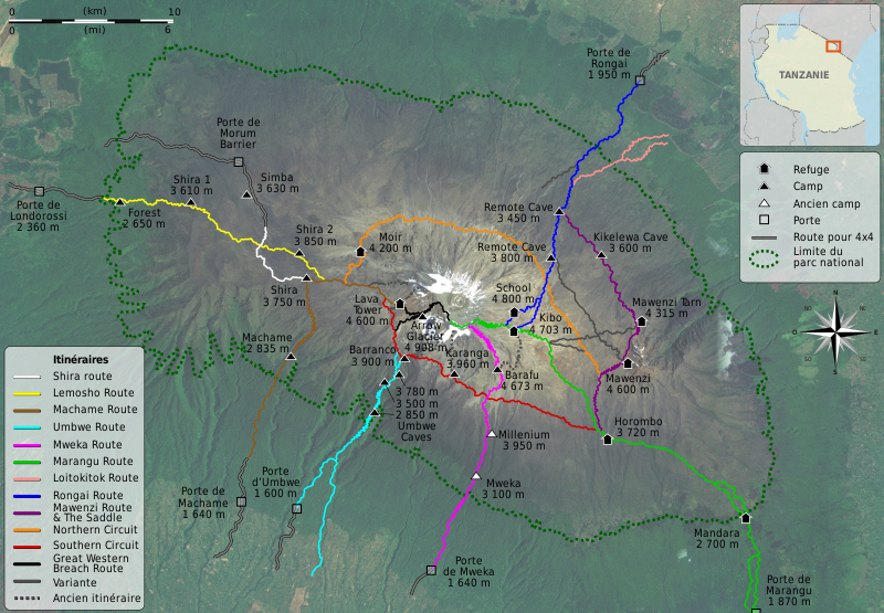
English: Map of the climbing routes and huts around the Mount Kilimanjaro. French version. Français : Carte des itinéraires et des camps et refuges autour du Kilimandjaro. |
||
| Date | |||
| Source |
|
||
| Author | Sémhur | ||
| Other versions |
| ||
| Attribution (required by the license) | © Sémhur / Wikimedia Commons / | ||
| SVG | W3C-validity not checked.
|
||
| Graphic Lab |


| Camera location | | View this and other nearby images on: OpenStreetMap |
|---|
Licensing[edit]
I, the copyright holder of this work, hereby publish it under the following licenses:
| Copyleft: This work of art is free; you can redistribute it and/or modify it according to terms of the Free Art License. You will find a specimen of this license on the Copyleft Attitude site as well as on other sites. |
This file is licensed under the Creative Commons Attribution-Share Alike 4.0 International, 3.0 Unported, 2.5 Generic, 2.0 Generic and 1.0 Generic license.
- You are free:
- to share – to copy, distribute and transmit the work
- to remix – to adapt the work
- Under the following conditions:
- attribution – You must give appropriate credit, provide a link to the license, and indicate if changes were made. You may do so in any reasonable manner, but not in any way that suggests the licensor endorses you or your use.
- share alike – If you remix, transform, or build upon the material, you must distribute your contributions under the same or compatible license as the original.
You may select the license of your choice.
File history
Click on a date/time to view the file as it appeared at that time.
| Date/Time | Thumbnail | Dimensions | User | Comment | |
|---|---|---|---|---|---|
| current | 17:02, 15 June 2009 | | 1,561 × 1,083 (1.36 MB) | Sémhur (talk | contribs) | Correct scale |
| 18:14, 29 April 2009 |  | 1,561 × 1,083 (1.36 MB) | Sémhur (talk | contribs) | With the bitmap... | |
| 18:10, 29 April 2009 |  | 1,561 × 1,083 (333 KB) | Sémhur (talk | contribs) | Few corrections | |
| 13:48, 29 April 2009 |  | 1,561 × 1,083 (1.35 MB) | Sémhur (talk | contribs) | More precise map | |
| 16:14, 27 April 2009 |  | 1,561 × 1,083 (1.15 MB) | Sémhur (talk | contribs) | {{Information |Description= {{en|Map of the climbing routes and huts around the Mount Kilimanjaro. French version.}} {{fr|Carte des itinéraires et des camps et refuges autour du Kilimandjaro.}} |Source=Trava |
You cannot overwrite this file.
File usage on Commons
The following 4 pages use this file:
File usage on other wikis
The following other wikis use this file:
- Usage on fr.wikipedia.org