File:Municipalities of Akita prefecture before 2004.png
Municipalities_of_Akita_prefecture_before_2004.png (240 × 300 pixels, file size: 83 KB, MIME type: image/png)
Captions
Captions
Summary[edit]
| Description |
English: Municipalities of Akita prefecture before 2004
日本語: 2004年以前の秋田県の市町村 |
| Date | |
| Source | Made by Enirac Sum, based on ja:画像:Japan map.png, ja:画像:Topographic N40E135 5deg.png, ja:画像:Topographic N35E140 5deg.png, ja:画像:Topographic N40E140 5deg.png, ja:画像:Topographic N35E135 5deg.png |
| Author | Enirac Sum |
説明[edit]
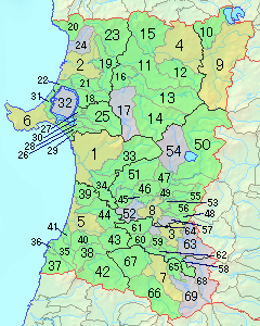
橙色の領域は市、緑色の領域は町、紫色の領域は村。薄い線は市町村の境界。濃い線は郡境界または旧郡境界。1:秋田市 2:能代市 3:横手市 4:大館市 5:本荘市 6:男鹿市 7:湯沢市 8:大曲市 9:鹿角市 10:小坂町 11:鷹巣町 12:比内町 13:森吉町 14:阿仁町 15:田代町 16:合川町 17:上小阿仁村 18:琴丘町 19:二ツ井町 20:八森町 21:山本町 22:八竜町 23:藤里町 24:峰浜村 25:五城目町 26:昭和町 27:八郎潟町 28:飯田川町 29:天王町 30:井川町 31:若美町 32:大潟村 33:河辺町 34:雄和町 35:仁賀保町 36:金浦町 37:象潟町 38:矢島町 39:岩城町 40:由利町 41:西目町 42:鳥海町 43:東由利町 44:大内町 45:神岡町 46:西仙北町 47:角館町 48:六郷町 49:中仙町 50:田沢湖町 51:協和町 52:南外村 53:仙北町 54:西木村 55:太田町 56:千畑町 57:仙南村 58:増田町 59:平鹿町 60:雄物川町 61:大森町 62:十文字町 63:山内村 64:大雄村 65:稲川町 66:雄勝町 67:羽後町 68:東成瀬村 69:皆瀬村
Summary[edit]
Orange areas show cities. Green areas show towns. Purple areas show villages. Light lines show borders of municipalities. Dark lines show borders of (old) districts. 1:Akita 2:Noshiro 3:Yokote 4:Ōdate 5:Honjō 6:Oga 7:Yuzawa 8:Ōmagari 9:Kazuno 10:Kosaka 11:Takanosu 12:Hinai 13:Moriyoshi 14:Ani 15:Tashiro 16:Aikawa 17:Kamikoani 18:Kotooka 19:Futatsui 20:Hachimori 21:Yamamoto 22:Hachiryū 23:Fujisato 24:Minehama 25:Gojōnome 26:Shōwa 27:Hachirōgata 28:Iitagawa 29:Tennō 30:Ikawa 31:Wakami 32:Ōgata 33:Kawabe 34:Yūwa 35:Nikaho 36:Konoura 37:Kisakata 38:Yashima 39:Iwaki 40:Yuri 41:Nishime 42:Chōkai 43:Higashiyuri 44:Ōuchi 45:Kamioka 46:Nishisemboku 47:Kakunodate 48:Rokugō 49:Nakasen 50:Tazawako 51:Kyōwa 52:Nangai 53:Semboku 54:Nishiki 55;Ōta 56:Senhata 57:Sennan 58:Masuda 59:Hiraka 60:Omonogawa 61:Ōmori 62:Jūmonji 63:Sannai 64:Taiyū 65:Inakawa 66:Ogachi 67:Ugo 68:Higashinaruse 69:Minase
Licensing[edit]

|
Permission is granted to copy, distribute and/or modify this document under the terms of the GNU Free Documentation License, Version 1.2 or any later version published by the Free Software Foundation; with no Invariant Sections, no Front-Cover Texts, and no Back-Cover Texts. A copy of the license is included in the section entitled GNU Free Documentation License. |
- You are free:
- to share – to copy, distribute and transmit the work
- to remix – to adapt the work
- Under the following conditions:
- attribution – You must give appropriate credit, provide a link to the license, and indicate if changes were made. You may do so in any reasonable manner, but not in any way that suggests the licensor endorses you or your use.
- share alike – If you remix, transform, or build upon the material, you must distribute your contributions under the same or compatible license as the original.
File history
Click on a date/time to view the file as it appeared at that time.
| Date/Time | Thumbnail | Dimensions | User | Comment | |
|---|---|---|---|---|---|
| current | 13:43, 31 October 2008 | | 240 × 300 (83 KB) | Enirac Sum (talk | contribs) | {{Information |Description={{en|1=Municipalities of Akita prefecture before 2004}} {{ja|1=2004年以前の秋田県の市町村}} |Source=Made by User:Enirac Sum, based on ja:画像:Japan map.png |Author=User:Enirac Sum |Date=October 31, 20 |
You cannot overwrite this file.
File usage on Commons
There are no pages that use this file.
File usage on other wikis
The following other wikis use this file:
- Usage on ja.wikipedia.org