File:MyanmarAyeyarwady.png
Jump to navigation
Jump to search
No higher resolution available.
MyanmarAyeyarwady.png (200 × 379 pixels, file size: 10 KB, MIME type: image/png)
Captions
Captions
Add a one-line explanation of what this file represents
Summary[edit]

|
This locator map image could be re-created using vector graphics as an SVG file. This has several advantages; see Commons:Media for cleanup for more information. If an SVG form of this image is available, please upload it and afterwards replace this template with
{{vector version available|new image name}}.
It is recommended to name the SVG file “MyanmarAyeyarwady.svg”—then the template Vector version available (or Vva) does not need the new image name parameter. |
| Description |
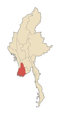
English: Ayeyarwady division in Myanmar |
| Date | uploaded to english Wikipedia 4 February 2006 |
| Source | taken from the english Wikipedia |
| Author |
Licensing[edit]

|
Permission is granted to copy, distribute and/or modify this document under the terms of the GNU Free Documentation License, Version 1.2 or any later version published by the Free Software Foundation; with no Invariant Sections, no Front-Cover Texts, and no Back-Cover Texts. A copy of the license is included in the section entitled GNU Free Documentation License. |
| This file is licensed under the Creative Commons Attribution-Share Alike 3.0 Unported license. | ||
| ||
| This licensing tag was added to this file as part of the GFDL licensing update. |
File history
Click on a date/time to view the file as it appeared at that time.
| Date/Time | Thumbnail | Dimensions | User | Comment | |
|---|---|---|---|---|---|
| current | 19:07, 19 December 2006 | | 200 × 379 (10 KB) | OHVChris75~commonswiki (talk | contribs) |
You cannot overwrite this file.
File usage on Commons
The following page uses this file:
File usage on other wikis
The following other wikis use this file:
- Usage on ace.wikipedia.org
- Usage on ca.wikipedia.org
- Usage on ceb.wikipedia.org
- Usage on de.wikipedia.org
- Usage on en.wikipedia.org
- Pyapon
- Hinthada
- Kyonpyaw
- Hinthada Township
- Bogale Township
- Nyaungdon Township
- Pathein District
- Hinthada District
- Myaungmya District
- Maubin District
- Pyapon District
- Kyaiklat Township
- Dedaye Township
- Kyaunggon Township
- Labutta Township
- Mawlamyinegyun Township
- Zalun Township
- Lemyethna Township
- Myanaung Township
- Yegyi Township
- Pyamalaw River
- Myanaung
- Mawlamyinegyun
- Pantanaw
- Danubyu
- Nyaungdon
- Einme
- Labutta
- Wakema
- Kangyidaunt
- Thabaung
- Ngapudaw
- Kyaunggon
- Yekyi
- Hainggyi Island (town)
- Ingapu
- Lemyethna
- Kyangin
- Myan Aung
- Kanaung
- Kyangin Township
- Dedaye
- Kyaiklat
- Agat, Myanmar
- Cyclone Nargis
- Template:Ayeyarwady-geo-stub
View more global usage of this file.