File:N570 France map fr.svg
Jump to navigation
Jump to search

Size of this PNG preview of this SVG file: 373 × 600 pixels. Other resolutions: 149 × 240 pixels | 298 × 480 pixels | 477 × 768 pixels | 637 × 1,024 pixels | 1,273 × 2,048 pixels | 1,737 × 2,793 pixels.
Original file (SVG file, nominally 1,737 × 2,793 pixels, file size: 140 KB)
Captions
Captions
Add a one-line explanation of what this file represents
| Description |
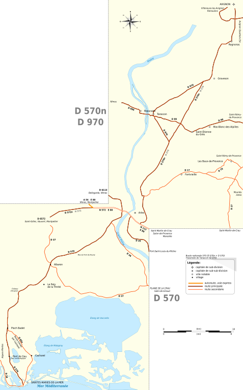
English: Map of N570 Avignon - Saintes-Maries-de-la-Mer (France). Inspired from OpenStreetMap data (cc-by-sa 2.0). Made with Inkscape.
Français : Carte de la RN 570 Avignon - Saintes-Maries-de-la-Mer (France). Inspiré des données OpenStreetMap (CC-BY-SA 2.0). Créé avec Inkscape. |
| Date | |
| Source | Own work |
| Author | Tabl-trai |
| Permission (Reusing this file) |
This file is licensed under the Creative Commons Attribution-Share Alike 2.0 France license.
 |
File history
Click on a date/time to view the file as it appeared at that time.
| Date/Time | Thumbnail | Dimensions | User | Comment | |
|---|---|---|---|---|---|
| current | 16:01, 5 July 2009 | | 1,737 × 2,793 (140 KB) | Tabl-trai (talk | contribs) | Le logiciel n'a pas tenu compte de la couleur de fond, rectangles sur la zone de travail de la carte |
| 15:54, 5 July 2009 |  | 1,737 × 2,793 (140 KB) | Tabl-trai (talk | contribs) | {{Information |Description={{en|1=Map of N570 Avignon - Saintes-Maries-de-la-Mer (France). Inspired from OpenStreetMap data (cc-by-sa 2.0). Made with Inkscape.}} {{fr|1=Carte de la RN 570 Avignon - Saintes-Maries-de-la-Mer (France). Inspiré des données |
You cannot overwrite this file.
File usage on Commons
There are no pages that use this file.
File usage on other wikis
The following other wikis use this file:
- Usage on fr.wikipedia.org