File:NPS theodore-roosevelt-regional-map.jpg
(Redirected from File:ND Map Roosevelt National Park.jpg)

No higher resolution available.
NPS_theodore-roosevelt-regional-map.jpg (550 × 394 pixels, file size: 142 KB, MIME type: image/jpeg)
Captions
Captions
Add a one-line explanation of what this file represents
Summary[edit]
| Description |
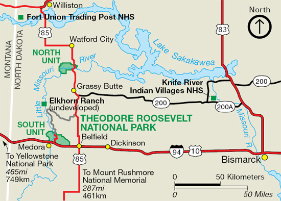
English: Regional map of Theodore Roosevelt National Park, showing its location in reference to I-94, other major roads, other national park sites, and towns in this area of western North Dakota. |
| Date | |
| Source | U.S. National Park Service (http://npmaps.com/wp-content/uploads/theodore-roosevelt-regional-map.jpg) |
| Author | U.S. National Park Service, restoration/cleanup by Matt Holly |
Licensing[edit]
| This image or media file contains material based on a work of a National Park Service employee, created as part of that person's official duties. As a work of the U.S. federal government, such work is in the public domain in the United States. See the NPS website and NPS copyright policy for more information. |
File history
Click on a date/time to view the file as it appeared at that time.
| Date/Time | Thumbnail | Dimensions | User | Comment | |
|---|---|---|---|---|---|
| current | 09:43, 17 May 2017 | | 550 × 394 (142 KB) | RKBot (talk | contribs) | =={{int:filedesc}}== {{Information |description= {{en|1=Regional map of Theodore Roosevelt National Park, showing its location in reference to I-94, other major roads, other national park sites, and towns in this area of western North Dakota.}} |date=... |
You cannot overwrite this file.
File usage on Commons
The following 3 pages use this file:
File usage on other wikis
The following other wikis use this file:
- Usage on de.wikipedia.org
- Usage on he.wikipedia.org
- Usage on it.wikipedia.org