File:Nationalpark Berchtesgaden in BGL.svg
Jump to navigation
Jump to search

Size of this PNG preview of this SVG file: 552 × 591 pixels. Other resolutions: 224 × 240 pixels | 448 × 480 pixels | 717 × 768 pixels | 956 × 1,024 pixels | 1,913 × 2,048 pixels.
Original file (SVG file, nominally 552 × 591 pixels, file size: 377 KB)
Captions
Captions
Add a one-line explanation of what this file represents
Summary[edit]
| Description |
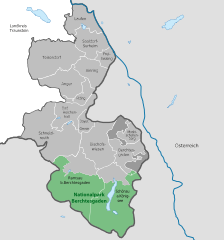
Deutsch: Nationalpark Berchtesgaden im Landkreis Berchtesgadener Land |
| Date | (UTC) |
| Source |
This file was derived from: Municipalities in BGL.svg |
| Author |
|
Licensing[edit]
This file is licensed under the Creative Commons Attribution-Share Alike 3.0 Unported license.
- You are free:
- to share – to copy, distribute and transmit the work
- to remix – to adapt the work
- Under the following conditions:
- attribution – You must give appropriate credit, provide a link to the license, and indicate if changes were made. You may do so in any reasonable manner, but not in any way that suggests the licensor endorses you or your use.
- share alike – If you remix, transform, or build upon the material, you must distribute your contributions under the same or compatible license as the original.
Original upload log[edit]
This image is a derivative work of the following images:
- File:Municipalities_in_BGL.svg licensed with Attribution, Cc-by-3.0,2.5,2.0,1.0, Cc-by-sa-3.0,2.5,2.0,1.0, Cc-zero, FAL, GFDL, PD-self
- 2012-04-13T17:19:19Z Inkowik 690x739 (989186 Bytes) - Forst St. Zeno
- 2010-09-17T11:23:07Z Hagar66 690x739 (985808 Bytes) {{Information |Description= |Source= |Date= |Author= |Permission= |other_versions= }}
- 2010-09-17T11:20:03Z Hagar66 690x739 (985468 Bytes)
- 2010-09-16T16:13:37Z TUBS 690x739 (983670 Bytes) corr
- 2010-09-14T08:04:46Z TUBS 690x739 (986417 Bytes) +major lakes +label placing improved
- 2010-05-27T08:19:34Z Hagar66 690x739 (942368 Bytes) {{Information |Description= {{DeLocMaps |mun= |munlink= |lk=Landkreis Berchtesgadener Land |enlk=District of Berchtesgadener Land |enlklink=Berchtesgadener Land |frlk=L'arrondissement de Berchtesgaden-Campagne |frlklink=Arron
- 2010-05-27T08:16:11Z Hagar66 690x739 (918296 Bytes) {{Information |Description= {{DeLocMaps |mun= |munlink= |lk=Landkreis Berchtesgadener Land |enlk=District of Berchtesgadener Land |enlklink=Berchtesgadener Land |frlk=L'arrondissement de Berchtesgaden-Campagne |frlklink=Arron

|
This map has been made or improved in the German Kartenwerkstatt (Map Lab). You can propose maps to improve as well.
|
File history
Click on a date/time to view the file as it appeared at that time.
| Date/Time | Thumbnail | Dimensions | User | Comment | |
|---|---|---|---|---|---|
| current | 18:04, 9 May 2012 | | 552 × 591 (377 KB) | NordNordWest (talk | contribs) | c |
| 18:59, 8 May 2012 |  | 552 × 591 (369 KB) | NordNordWest (talk | contribs) | == {{int:filedesc}} == {{Information |Description={{de|Nationalpark Berchtesgaden im Landkreis Berchtesgadener Land}} |Source={{Derived from|Municipalities_in_BGL.svg}} |Date=2012-05-08 18:56 (UTC) |Author=*File:Municipalities_in_BGL.svg: [[User:... |
You cannot overwrite this file.
File usage on Commons
The following 2 pages use this file:
File usage on other wikis
The following other wikis use this file:
- Usage on de.wikipedia.org
- Usage on eo.wikipedia.org
- Usage on es.wikipedia.org
- Usage on pl.wikipedia.org
- Usage on vi.wikipedia.org