File:New Orleans elevation relative to Lake Pontchartrain.jpg
Jump to navigation
Jump to search
Size of this preview: 800 × 560 pixels. Other resolutions: 320 × 224 pixels | 640 × 448 pixels | 1,024 × 717 pixels | 1,333 × 933 pixels.
Original file (1,333 × 933 pixels, file size: 1.42 MB, MIME type: image/jpeg)
Captions
Captions
Add a one-line explanation of what this file represents
Summary[edit]
| Description |
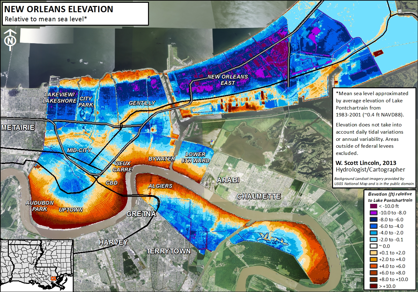
English: Map shows the elevation of New Orleans proper, relative to Lake Pontchartrain average elevation, in feet. |
| Date | |
| Source | Created as a compilation of geospatial data either created by myself or taken from public domain data. Also published in a National Weather Service Technical Paper by Lincoln & Schlotzhauer (2013) [1] & Schlotzhauer & Lincoln (2016) [2] |
| Author | Slincoln |
- Other information
English: The underlying aerial imagery is from Landsat and was retrieved from the USGS National Map. USGS orthoimagery for Louisiana is in the public domain (http://cumulus.cr.usgs.gov/listofortho.php). The underlying elevation data was analyzed by myself based upon high resolution elevation data also available from the USGS National Map.
Licensing[edit]
Underlying image:
This image is in the public domain in the United States because it only contains materials that originally came from the United States Geological Survey, an agency of the United States Department of the Interior. For more information, see the official USGS copyright policy.
|
This image is in the public domain because it contains materials that originally came from the U.S. National Oceanic and Atmospheric Administration, taken or made as part of an employee's official duties.
|
This modified image:
I, the copyright holder of this work, hereby publish it under the following licenses:

|
Permission is granted to copy, distribute and/or modify this document under the terms of the GNU Free Documentation License, Version 1.2 or any later version published by the Free Software Foundation; with no Invariant Sections, no Front-Cover Texts, and no Back-Cover Texts. A copy of the license is included in the section entitled GNU Free Documentation License. |
This file is licensed under the Creative Commons Attribution-Share Alike 4.0 International, 3.0 Unported, 2.5 Generic, 2.0 Generic and 1.0 Generic license.
- You are free:
- to share – to copy, distribute and transmit the work
- to remix – to adapt the work
- Under the following conditions:
- attribution – You must give appropriate credit, provide a link to the license, and indicate if changes were made. You may do so in any reasonable manner, but not in any way that suggests the licensor endorses you or your use.
- share alike – If you remix, transform, or build upon the material, you must distribute your contributions under the same or compatible license as the original.
You may select the license of your choice.
File history
Click on a date/time to view the file as it appeared at that time.
| Date/Time | Thumbnail | Dimensions | User | Comment | |
|---|---|---|---|---|---|
| current | 19:02, 5 March 2014 | | 1,333 × 933 (1.42 MB) | Slincoln (talk | contribs) | {{subst:Upload marker added by en.wp UW}} {{Information |Description = {{en|Map shows the elevation of New Orleans proper, relative to Lake Pontchartrain average elevation, in feet.}} |Source = Created as a compilation of geospatial data either created... |
You cannot overwrite this file.
File usage on Commons
There are no pages that use this file.