File:New map of that part of the city of New York south from 20th Street on the Hudson and 35th Street on the East River - showing the position of Greenwich, Washington and West Streets on the NYPL1696576.tiff
Jump to navigation
Jump to search

Size of this JPG preview of this TIF file: 427 × 600 pixels. Other resolutions: 171 × 240 pixels | 342 × 480 pixels | 547 × 768 pixels | 729 × 1,024 pixels | 1,458 × 2,048 pixels | 6,607 × 9,280 pixels.
Original file (6,607 × 9,280 pixels, file size: 175.45 MB, MIME type: image/tiff)
Captions
Captions
Add a one-line explanation of what this file represents
Summary[edit]
| Description | New map of that part of the city of New York south from 20th Street on the Hudson and 35th Street on the East River : showing the position of Greenwich, Washington and West Streets on the Hudson River, and Pearl, Water, Front, Cherry and Tompkins Sts. on the East River : also the Brooklyn shore from Bobine House to Red Hook Point : also the high and low water mark as developed from the original city grants : the ordinance lines of 1795, 1796 and 1808 and the lawful boundary of the city / ... by O.W. Childs, civil engr. ; S.H. Sweet, principal assistant ; E. Smith and R. Graves, city surveyors ; J. Burke, draftsman ; H.F. Greene, assistant draftsman ; D. Vaughan, scrip.; Maps of New York City and State / New York City / Manhattan | |||||||||||||||||||||||
| Notes | "Made under the act, Chap. 516 Laws of 1860, pursuant to instructions from Van R. Richmond, state engineer and surveyor." ''Note 2.'') Also shows original shore and ferry lines. ''Note 3.'') Includes tables of statistics regarding reclaimed land. ''Note 4.'') NYPL copy dissected into 2 sheets, 52 x 67 cm. and 45 x 66 cm. | |||||||||||||||||||||||
| Item physical description | 1 map : hand col. ; 95 x 65 cm. | |||||||||||||||||||||||
| Catalogue call number | Map Div. 09-1209 | |||||||||||||||||||||||
| Date | ||||||||||||||||||||||||
| Source |
http://digitalgallery.nypl.org/nypldigital/dgkeysearchdetail.cfm?imageID=1696576
|
|||||||||||||||||||||||
| Author | ||||||||||||||||||||||||
| Permission (Reusing this file) |
From The Lionel Pincus and Princess Firyal Map Division. http://maps.nypl.org
|
|||||||||||||||||||||||
| Location | Stephen A. Schwarzman Building / The Lionel Pincus and Princess Firyal Map Division | |||||||||||||||||||||||
| Digital item published | 3-10-2009; updated 5-16-2012 | |||||||||||||||||||||||
| Digital ID | 1696576 | |||||||||||||||||||||||

The making of this file was supported by Wikimedia UK.
To see other files made with the support of Wikimedia UK, please see the category Supported by Wikimedia UK.
|
File history
Click on a date/time to view the file as it appeared at that time.
| Date/Time | Thumbnail | Dimensions | User | Comment | |
|---|---|---|---|---|---|
| current | 07:37, 2 May 2014 | 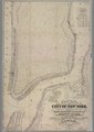 | 6,607 × 9,280 (175.45 MB) | Fæ (talk | contribs) | GWToolset:: Creating mediafile for Fæ. Tranche 3 11591-16518 @ 2 May, 06:47 BST |
You cannot overwrite this file.
File usage on Commons
There are no pages that use this file.