File:NoerdlingerRies topo.jpg
Jump to navigation
Jump to search
Size of this preview: 800 × 592 pixels. Other resolutions: 320 × 237 pixels | 640 × 474 pixels | 1,000 × 740 pixels.
Original file (1,000 × 740 pixels, file size: 255 KB, MIME type: image/jpeg)
Captions
Captions
Add a one-line explanation of what this file represents
Summary[edit]
| Description |
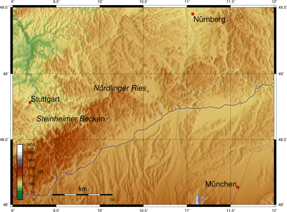
Deutsch: Topografische Karte mit dem Nördlinger Ries und dem Steinheimer Becken.
Español: Mapa topográfica con el Ries de Nördlingen.
Suomi: Nördlinger Riesin kraatteri näkyy hyvin riittävän tarkassa korkokuvakartassa ympyrämäisenä painumana.
Français : Carte topographique avec le Nördlinger Ries. |
| Source | |
| Author | User Captain Blood on de.wikipedia |
| Other versions |
Originally from de.wikipedia; description page is (was) here * 15:22, 10. Dez 2005 [[:de:User:Captain Blood|Captain Blood]] 1000 x 740 (260.796 Bytes) * 20:06, 11. Nov 2005 [[:de:User:Captain Blood|Captain Blood]] 1200 x 909 (438.871 Bytes) <span class="comment">({{GFDL}})</span> |

|
Permission is granted to copy, distribute and/or modify this document under the terms of the GNU Free Documentation License, Version 1.2 or any later version published by the Free Software Foundation; with no Invariant Sections, no Front-Cover Texts, and no Back-Cover Texts. A copy of the license is included in the section entitled GNU Free Documentation License. |
| This file is licensed under the Creative Commons Attribution-Share Alike 3.0 Unported license. | ||
| ||
| This licensing tag was added to this file as part of the GFDL licensing update. |
(Uploaded using CommonsHelper or PushForCommons)
Bei der Erstellung der Landkarte wurden die Generic Mapping Tools verwendet: http://gmt.soest.hawaii.edu/ archive copy at the Wayback Machine
Für das Relief - falls vorhanden - wurde(n) einer oder mehrere dieser externen Public Domain-Datensätze verwendet:
- ETOPO2 (Auflösung 2′ = 3,6km am Äquator) http://dss.ucar.edu/datasets/ds759.3 archive copy at the Wayback Machine
- GLOBE (30″ = 0,9km) http://www.ngdc.noaa.gov/mgg/topo/gltiles.html
- SRTM (Shuttle Radar Topography Mission) (3″ = 90m) http://www2.jpl.nasa.gov/srtm/index.html
File history
Click on a date/time to view the file as it appeared at that time.
| Date/Time | Thumbnail | Dimensions | User | Comment | |
|---|---|---|---|---|---|
| current | 12:54, 30 August 2006 | | 1,000 × 740 (255 KB) | Gaeddal (talk | contribs) | {{Information| |Description= |Source= |Date= |Author=User Captain Blood on [http://de.wikipedia.org de.wikipedia] |Permission=Released under the GNU Free Documentation License. |other_versions= Originally from [http://de.wi |
You cannot overwrite this file.
File usage on Commons
The following page uses this file:
File usage on other wikis
The following other wikis use this file:
- Usage on ca.wikipedia.org
- Usage on de.wikipedia.org
- Usage on en.wikipedia.org
- Usage on es.wikipedia.org
- Usage on fi.wikipedia.org
- Usage on fr.wikipedia.org
- Usage on ro.wikipedia.org