File:OIA.svg
Jump to navigation
Jump to search

Size of this PNG preview of this SVG file: 652 × 599 pixels. Other resolutions: 261 × 240 pixels | 522 × 480 pixels | 835 × 768 pixels | 1,114 × 1,024 pixels | 2,228 × 2,048 pixels | 2,196 × 2,019 pixels.
Original file (SVG file, nominally 2,196 × 2,019 pixels, file size: 1.33 MB)
Captions
Captions
Add a one-line explanation of what this file represents
Summary[edit]
| Description |
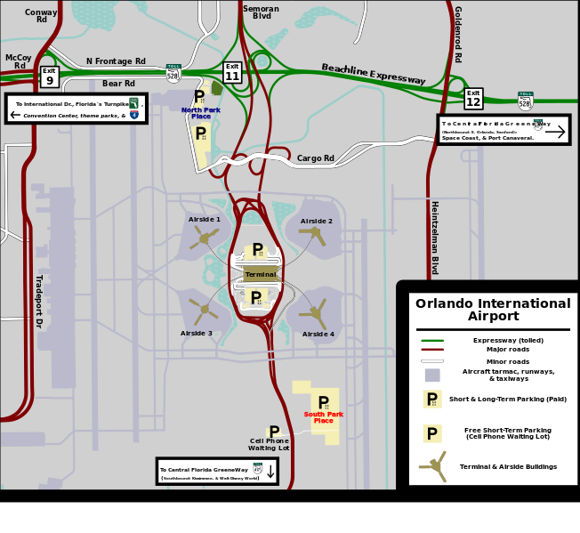
English: Overview map of Orlando International Airport. (Note to editors: This was made for the O.I.A. guide on Wikivoyage. Please do not change style.) |
| Date | |
| Source | Own work |
| Author | AHeneen |
| Other versions | File:Orlando International Airport.png |
| Camera location | | View this and other nearby images on: OpenStreetMap |
|---|
| This work contains information from OpenStreetMap, which is made available under the Open Database License (ODbL).
The ODbL does not require any particular license for maps produced from ODbL data. Prior to 1 August 2020, map tiles produced by the OpenStreetMap Foundation were licensed under the CC-BY-SA-2.0 license. Maps produced by other people may be subject to other licences. |
Licensing[edit]
I, the copyright holder of this work, hereby publish it under the following license:
This file is licensed under the Creative Commons Attribution-Share Alike 3.0 Unported license.
- You are free:
- to share – to copy, distribute and transmit the work
- to remix – to adapt the work
- Under the following conditions:
- attribution – You must give appropriate credit, provide a link to the license, and indicate if changes were made. You may do so in any reasonable manner, but not in any way that suggests the licensor endorses you or your use.
- share alike – If you remix, transform, or build upon the material, you must distribute your contributions under the same or compatible license as the original.
File history
Click on a date/time to view the file as it appeared at that time.
| Date/Time | Thumbnail | Dimensions | User | Comment | |
|---|---|---|---|---|---|
| current | 02:30, 23 April 2013 | | 2,196 × 2,019 (1.33 MB) | AHeneen (talk | contribs) | Added labels for destinations along SR528 & South Access Road. Added rectangle for extent of Cell Phone Waiting lot and edited South Park Place & their access roads. |
| 10:50, 21 April 2013 |  | 2,196 × 2,019 (1.28 MB) | AHeneen (talk | contribs) | User created page with UploadWizard |
You cannot overwrite this file.
File usage on Commons
The following page uses this file: