File:Offshore transformer in Belfast Lough - geograph.org.uk - 1535206.jpg
Offshore_transformer_in_Belfast_Lough_-_geograph.org.uk_-_1535206.jpg (640 × 337 pixels, file size: 77 KB, MIME type: image/jpeg)
Captions
Captions
Summary[edit]
| Description |
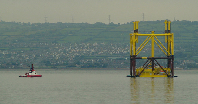
English: Offshore transformer in Belfast Lough 7,500 tonne offshore transformer platform being towed from Belfast to the North Sea. The structure is seen here in Belfast Lough midway between Helen's Bay (my position) and Carrickfergus. The entire structure is to be known as transformer 'Bard 1'.
The steel superstructure of the transformer - which is actually the subsea foundation, or substructure - had just been completed in the building dock of Harland and Wolff, where it was attached to the 'yellow box' at the bottom - actually the Latvian built transformer which also houses a canteen, health clinic and sleeping quarters for 30 people. Two tugboats, the 'Bugsier 9' (unseen) and the 'Taucher O. Wulf 4' 1500049 then escorted the structure from Belfast towards its final destination - around 90 miles north of the German island of Borkum in the North Sea. Once there the self installing transformer will lower the substructure onto the seabed and lift itself out of the water. Connected to 60 offshore wind turbines, it will produce around 400MW of electricity by increasing the voltage of the alternating current from the windfarms from 33kV to 155kV before the power is transferred to a neighbouring converter platform and sent back to Germany for connection to the electricity network. See also https://www.geograph.org.uk/search.php?i=8465806 for some related images of the construction. |
| Date | |
| Source | From geograph.org.uk |
| Author | Ross |
| Camera location | | View this and other nearby images on: OpenStreetMap |
|---|
_heading:0.00&language=en)
| Object location | | View this and other nearby images on: OpenStreetMap |
|---|
_heading:0.00&language=en)
Licensing[edit]

|
This image was taken from the Geograph project collection. See this photograph's page on the Geograph website for the photographer's contact details. The copyright on this image is owned by Ross and is licensed for reuse under the Creative Commons Attribution-ShareAlike 2.0 license.
|
- You are free:
- to share – to copy, distribute and transmit the work
- to remix – to adapt the work
- Under the following conditions:
- attribution – You must give appropriate credit, provide a link to the license, and indicate if changes were made. You may do so in any reasonable manner, but not in any way that suggests the licensor endorses you or your use.
- share alike – If you remix, transform, or build upon the material, you must distribute your contributions under the same or compatible license as the original.
File history
Click on a date/time to view the file as it appeared at that time.
| Date/Time | Thumbnail | Dimensions | User | Comment | |
|---|---|---|---|---|---|
| current | 07:06, 3 March 2011 | | 640 × 337 (77 KB) | GeographBot (talk | contribs) | == {{int:filedesc}} == {{Information |description={{en|1=Offshore transformer in Belfast Lough 7,500 tonne offshore transformer platform being towed from Belfast to the North Sea. The structure is seen here in Belfast Lough midway between Helen's Bay (my |
You cannot overwrite this file.
File usage on Commons
There are no pages that use this file.