File:Olivenza1766.jpg
Jump to navigation
Jump to search

Size of this preview: 800 × 599 pixels. Other resolutions: 320 × 239 pixels | 640 × 479 pixels | 1,024 × 766 pixels | 1,331 × 996 pixels.
Original file (1,331 × 996 pixels, file size: 575 KB, MIME type: image/jpeg)
Captions
Captions
Add a one-line explanation of what this file represents
Summary[edit]
| Description |
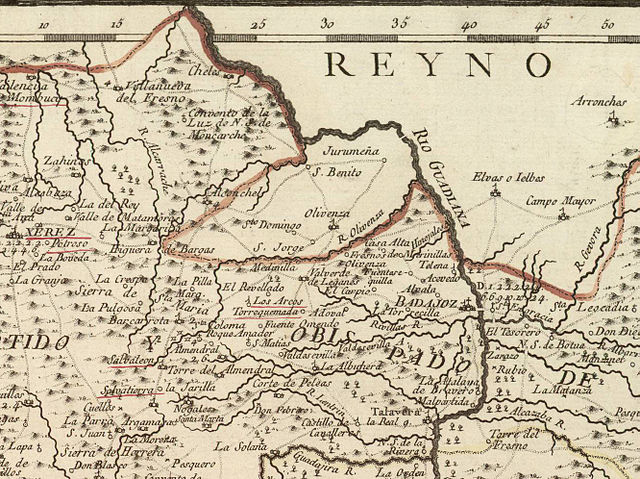
Español: Olivenza y comarcas cercanas en un mapa de la "provincia de Estremadura" publicado por Tomás López en 1766. Nótese que la orientación del mapa es inusual, con el oeste arriba. La línea roja gruesa representa la frontera entre España y Portugal, país al que Olivenza pertenecía por aquel entonces. |
|||||||||||||||||||
| Date | ||||||||||||||||||||
| Source | Real Academia de la Historia | |||||||||||||||||||
| Author |
|
|||||||||||||||||||
| Permission (Reusing this file) |
|
|||||||||||||||||||
Esta imagen es un fragmento de File:Mapa de la provincia de Estremadura (1766).jpg
.jpg)
File history
Click on a date/time to view the file as it appeared at that time.
| Date/Time | Thumbnail | Dimensions | User | Comment | |
|---|---|---|---|---|---|
| current | 03:59, 28 July 2012 | | 1,331 × 996 (575 KB) | Hispalois (talk | contribs) |
You cannot overwrite this file.
File usage on Commons
There are no pages that use this file.
File usage on other wikis
The following other wikis use this file:
- Usage on azb.wikipedia.org
- Usage on es.wikipedia.org