File:Oregon Rivers.png
Jump to navigation
Jump to search
Size of this preview: 800 × 600 pixels. Other resolutions: 320 × 240 pixels | 640 × 480 pixels | 1,024 × 768 pixels | 1,280 × 960 pixels | 1,500 × 1,125 pixels.
Original file (1,500 × 1,125 pixels, file size: 3.37 MB, MIME type: image/png)
Captions
Captions
Add a one-line explanation of what this file represents
Summary[edit]
| Description | |
| Date | |
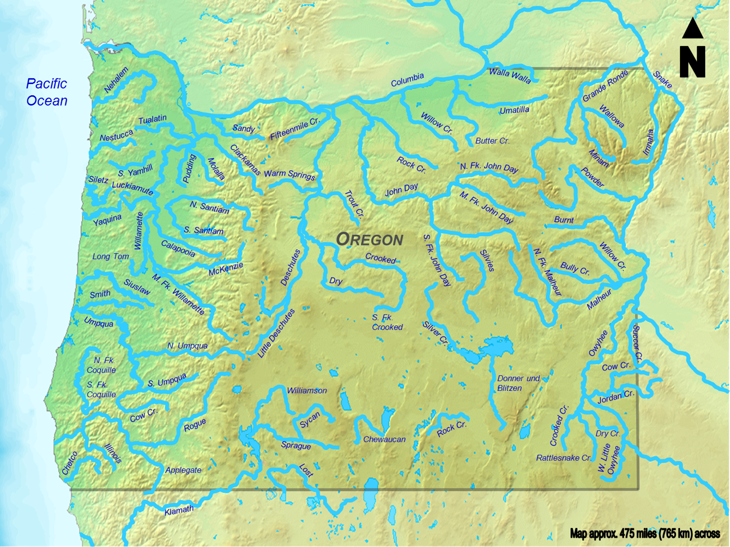
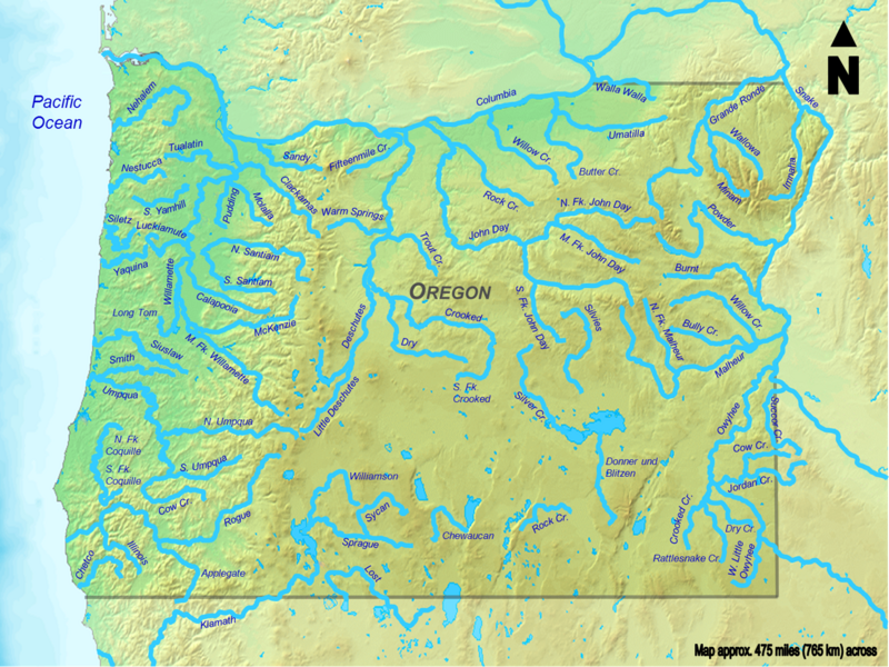
| Source | Background taken from the Demis Map Server and modified by Little Mountain 5. Stream courses copied from a variety of different sources. |
| Author | Demis Map Server, Little Mountain 5 |
Licensing[edit]
I, the copyright holder of this work, hereby publish it under the following licenses:
This file is licensed under the Creative Commons Attribution-Share Alike 3.0 Unported license.
- You are free:
- to share – to copy, distribute and transmit the work
- to remix – to adapt the work
- Under the following conditions:
- attribution – You must give appropriate credit, provide a link to the license, and indicate if changes were made. You may do so in any reasonable manner, but not in any way that suggests the licensor endorses you or your use.
- share alike – If you remix, transform, or build upon the material, you must distribute your contributions under the same or compatible license as the original.

|
Permission is granted to copy, distribute and/or modify this document under the terms of the GNU Free Documentation License, Version 1.2 or any later version published by the Free Software Foundation; with no Invariant Sections, no Front-Cover Texts, and no Back-Cover Texts. A copy of the license is included in the section entitled GNU Free Documentation License. |
You may select the license of your choice.
File history
Click on a date/time to view the file as it appeared at that time.
| Date/Time | Thumbnail | Dimensions | User | Comment | |
|---|---|---|---|---|---|
| current | 15:58, 9 August 2011 | | 1,500 × 1,125 (3.37 MB) | Little Mountain 5 (talk | contribs) | Add Minam, label fixes |
| 22:16, 20 September 2010 |  | 1,500 × 1,125 (2.91 MB) | Little Mountain 5 (talk | contribs) | Shorten Illinois | |
| 23:09, 13 September 2010 |  | 1,500 × 1,125 (2.91 MB) | Little Mountain 5 (talk | contribs) | rm pink cities, tweak note at bottom | |
| 23:19, 3 September 2010 |  | 1,500 × 1,125 (2.91 MB) | Little Mountain 5 (talk | contribs) | Add Walla Walla label | |
| 23:07, 3 September 2010 |  | 1,500 × 1,125 (2.9 MB) | Little Mountain 5 (talk | contribs) | Add a few more; I think that's it for now | |
| 18:15, 3 September 2010 |  | 1,500 × 1,125 (2.9 MB) | Little Mountain 5 (talk | contribs) | Update; still a few more to go. | |
| 17:18, 2 September 2010 |  | 1,500 × 1,125 (2.87 MB) | Little Mountain 5 (talk | contribs) | {{Information |Description={{en|1=A map of all the rivers in Oregon over {{convert|50|mi|km}} in length, as listed here.}} |Source=Background taken from the [http://www2.demis.nl/mapserver/mapper.asp Demis Map Serve |
You cannot overwrite this file.
File usage on Commons
There are no pages that use this file.
File usage on other wikis
The following other wikis use this file:
- Usage on bg.wikipedia.org
- Usage on en.wikipedia.org
- User talk:Golbez/Archive 4
- User:Little Mountain 5/Images
- User talk:Nergaal/Archive 5
- User talk:Ruhrfisch/Archive30
- List of longest streams of Oregon
- User talk:Ucucha/Archive23
- User:Gerry D/archive19
- Template:Longest streams of Oregon map
- User talk:Kmusser/Archive6
- Talk:List of longest streams of Oregon/Archive 1
- User talk:H1nkles/Archive 4
- User talk:Pfly/Archive 6
- User:Little Mountain 5
- Usage on es.wikipedia.org
- Usage on fi.wikipedia.org