File:Orly Aerodrome - Airfield Maps.jpg
Jump to navigation
Jump to search

Size of this preview: 718 × 599 pixels. Other resolutions: 288 × 240 pixels | 575 × 480 pixels | 920 × 768 pixels | 1,193 × 996 pixels.
Original file (1,193 × 996 pixels, file size: 193 KB, MIME type: image/jpeg)
Captions
Captions
Add a one-line explanation of what this file represents
Summary[edit]
| Description |
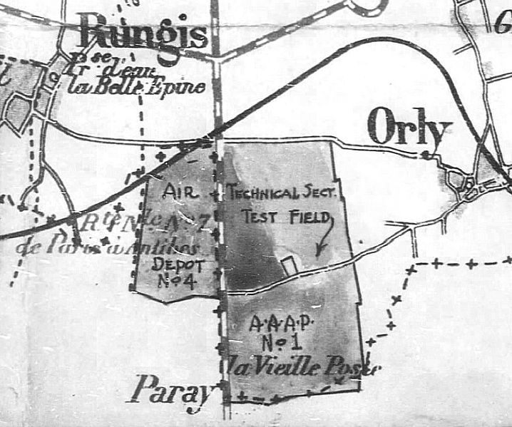
English: Orly Aerodrome - Airfield Location Maps |
| Date | |
| Source | Air Service, United States Army via Series 1, Paris Headquarters and Supply Section, Volume 21 History of American Aviation Acceptance Park No. 1 at Orly |
| Author | Air Service, United States Army |
| Permission (Reusing this file) |
USGOV-PD |
Licensing[edit]
This work is in the public domain in the United States because it was published (or registered with the U.S. Copyright Office) before January 1, 1929.
Public domain works must be out of copyright in both the United States and in the source country of the work in order to be hosted on the Commons. If the work is not a U.S. work, the file must have an additional copyright tag indicating the copyright status in the source country.
Note: This tag should not be used for sound recordings. |
File history
Click on a date/time to view the file as it appeared at that time.
| Date/Time | Thumbnail | Dimensions | User | Comment | |
|---|---|---|---|---|---|
| current | 16:34, 13 May 2014 | | 1,193 × 996 (193 KB) | Bwmoll3 (talk | contribs) | == {{int:filedesc}} == {{Information |Description ={{en|1=Orly Aerodrome - Airfield Location Maps}} |Source =Air Service, United States Army via Series 1, Paris Headquarters and Supply Section, Volume 21 History of American Aviation Accept... |
You cannot overwrite this file.
File usage on Commons
The following page uses this file:
File usage on other wikis
The following other wikis use this file:
- Usage on en.wikipedia.org