File:PSC Direct Flights.png
Jump to navigation
Jump to search

Size of this preview: 800 × 495 pixels. Other resolutions: 320 × 198 pixels | 640 × 396 pixels | 1,181 × 731 pixels.
Original file (1,181 × 731 pixels, file size: 200 KB, MIME type: image/png)
Captions
Captions
Add a one-line explanation of what this file represents
Summary[edit]
| Description |
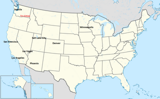
English: A map of airports that provide direct flights to the Tri-Cities Airport with the Tri-Cities Airport in red. |
| Date | |
| Source | Own work |
| Author | Weathermiz |
Licensing[edit]
I, the copyright holder of this work, hereby publish it under the following license:
This file is licensed under the Creative Commons Attribution 3.0 Unported license.
- You are free:
- to share – to copy, distribute and transmit the work
- to remix – to adapt the work
- Under the following conditions:
- attribution – You must give appropriate credit, provide a link to the license, and indicate if changes were made. You may do so in any reasonable manner, but not in any way that suggests the licensor endorses you or your use.
File history
Click on a date/time to view the file as it appeared at that time.
| Date/Time | Thumbnail | Dimensions | User | Comment | |
|---|---|---|---|---|---|
| current | 05:55, 24 January 2012 | | 1,181 × 731 (200 KB) | Weathermiz (talk | contribs) | {{Information |Description ={{en|1=A map of airports that provide direct flights to the Tri-Cities Airport with the Tri-Cities Airport in red.}} |Source ={{own}} |Author =[[User:Weathermiz|Weathermiz] |
You cannot overwrite this file.
File usage on Commons
There are no pages that use this file.