File:Panorama Gersfeld.jpg
Jump to navigation
Jump to search

Size of this preview: 799 × 233 pixels. Other resolutions: 320 × 93 pixels | 640 × 187 pixels | 1,024 × 299 pixels | 1,280 × 373 pixels | 5,500 × 1,604 pixels.
Original file (5,500 × 1,604 pixels, file size: 1.97 MB, MIME type: image/jpeg)
Captions
Captions
Add a one-line explanation of what this file represents
Summary[edit]
| Description |
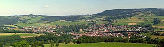
Deutsch: Gersfeld (Rhön), auf etwa 400 Meter über Normal Null gelegen, ist eine als Luftkurort und Kneipp-Heilbad anerkannte Stadt inmitten der hessischen Rhön. Rechts oben die Wasserkuppe mit Radarkuppel, mit einer Höhe von 950 Meter höchster Berg der Rhön. Links oben der 705 Meter hohe Wachtküppel. Mitte oben das Fuldaer Haus vor der 706 Meter hohen Maulkuppe. |
| Date | |
| Source | Own work |
| Author | Rainer Lippert |
| Camera location | | View this and other nearby images on: OpenStreetMap |
|---|
This image was created with Hugin.
Licensing[edit]
| I, the copyright holder of this work, release this work into the public domain. This applies worldwide. In some countries this may not be legally possible; if so: I grant anyone the right to use this work for any purpose, without any conditions, unless such conditions are required by law. |
File history
Click on a date/time to view the file as it appeared at that time.
| Date/Time | Thumbnail | Dimensions | User | Comment | |
|---|---|---|---|---|---|
| current | 17:05, 12 August 2010 | 5,500 × 1,604 (1.97 MB) | Rainer Lippert (talk | contribs) | {{Information |Description=Gersfeld |Source={{own}} |Date=19. Juni 2010 |Author=Rainer Lippert |Permission= |other_versions= }} |
You cannot overwrite this file.
File usage on Commons
The following 2 pages use this file: