File:Paramoudra surrounded by seaweed - geograph.org.uk - 793054.jpg
Jump to navigation
Jump to search

Size of this preview: 450 × 600 pixels. Other resolutions: 180 × 240 pixels | 480 × 640 pixels.
Original file (480 × 640 pixels, file size: 192 KB, MIME type: image/jpeg)
Captions
Captions
Add a one-line explanation of what this file represents
Summary[edit]
| Description |
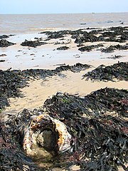
English: Paramoudra surrounded by seaweed. Flint nodules such as the one seen here are called paramoudras. These large nodules were once embedded in the chalk layer; some have a central core that is filled with chalk but once exposed the soft chalk is quickly washed out by wave action, leaving a large hole. The paramoudra seen here still has some of its chalk core left. Another name for these paramoudras is pot stone; specimens can be spotted in gardens where they serve as nature-made flower pots. |
||
| Date | |||
| Source | From geograph.org.uk | ||
| Author | Evelyn Simak | ||
| Permission (Reusing this file) |
This file is licensed under the Creative Commons Attribution-Share Alike 2.0 Generic license. Attribution: Evelyn Simak
|
||
| Attribution (required by the license) | Evelyn Simak / Paramoudra surrounded by seaweed / | ||

| Camera location | | View this and other nearby images on: OpenStreetMap |
|---|
_heading:45.00&language=en)
| Object location | | View this and other nearby images on: OpenStreetMap |
|---|
_heading:45.00&language=en)
File history
Click on a date/time to view the file as it appeared at that time.
| Date/Time | Thumbnail | Dimensions | User | Comment | |
|---|---|---|---|---|---|
| current | 05:35, 20 February 2011 | | 480 × 640 (192 KB) | GeographBot (talk | contribs) | == {{int:filedesc}} == {{Information |description={{en|1=Paramoudra surrounded by seaweed Flint nodules such as the one seen here are called paramoudras. These large nodules were once embedded in the chalk layer; some have a central core that is filled wi |
You cannot overwrite this file.
File usage on Commons
There are no pages that use this file.