File:Map of Phillip Island, Victoria.png
(Redirected from File:Philmap1.PNG)

Size of this preview: 800 × 563 pixels. Other resolutions: 320 × 225 pixels | 640 × 450 pixels | 888 × 625 pixels.
Original file (888 × 625 pixels, file size: 55 KB, MIME type: image/png)
Captions
Captions
Add a one-line explanation of what this file represents
Summary[edit]
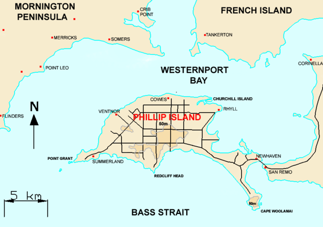
| Description | Map of Phillip Island, Victoria |
| Date | |
| Source | Original Uploader was Lentisco (talk) at 04:05, 7 August 2006. |
| Author | Lentisco |
Licensing[edit]
| This work has been released into the public domain by its author, Lentisco at English Wikipedia. This applies worldwide. In some countries this may not be legally possible; if so: Lentisco grants anyone the right to use this work for any purpose, without any conditions, unless such conditions are required by law. |
File history
Click on a date/time to view the file as it appeared at that time.
| Date/Time | Thumbnail | Dimensions | User | Comment | |
|---|---|---|---|---|---|
| current | 16:23, 4 March 2018 | | 888 × 625 (55 KB) | HerrAdams (talk | contribs) | Removed border by cropping 3 % horizontally and 4 % vertically using CropTool with precise mode. |
| 16:59, 19 July 2007 |  | 915 × 651 (62 KB) | Aconcagua (talk | contribs) | {{Information |Description=Map of Phillip Island, Victoria |Source={{Moved to commons|en|Lentisco|04:05, 7 August 2006}} |Date=7 August 2006 |Author=Lentisco |Permission= |other_versions= }} {{PD-user-en|Lentisco}} |
You cannot overwrite this file.
File usage on Commons
The following page uses this file:
- File:Philmap1.PNG (file redirect)
File usage on other wikis
The following other wikis use this file:
- Usage on de.wikipedia.org
- Usage on en.wikipedia.org
- Usage on eo.wikipedia.org
- Usage on es.wikipedia.org
- Usage on fa.wikipedia.org
- Usage on hi.wikipedia.org
- Usage on it.wikipedia.org
- Usage on ja.wikipedia.org
- Usage on ko.wikipedia.org
- Usage on pl.wikipedia.org
- Usage on simple.wikipedia.org
- Usage on sv.wikipedia.org
- Usage on uk.wikipedia.org