File:Piloto Pardo Islands Map.png
Jump to navigation
Jump to search

Size of this preview: 800 × 467 pixels. Other resolutions: 320 × 187 pixels | 640 × 374 pixels | 1,164 × 680 pixels.
Original file (1,164 × 680 pixels, file size: 264 KB, MIME type: image/png)
Captions
Captions
Add a one-line explanation of what this file represents
Summary[edit]
| Description |
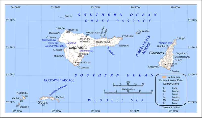
English: Piloto Pardo Islands Map. Conic A projection. Standard parallel -61.25 ATTENTION: In British Antarctic maps (not in Argentina and Chile), “Prince Charles Passage” is called Prince Charles Strait and is between Elephant Island and Cornwallis Island and NOT between Elephant Island and Clarence Island! See also: → Map 13676: South Shetland Islands by UK Antarctic Place-names Committee. |
| Date | |
| Source | Own work |
| Author | Gi |
| Other versions |
|
Licensing[edit]
I, the copyright holder of this work, hereby publish it under the following license:
This file is licensed under the Creative Commons Attribution-Share Alike 3.0 Unported license.
- You are free:
- to share – to copy, distribute and transmit the work
- to remix – to adapt the work
- Under the following conditions:
- attribution – You must give appropriate credit, provide a link to the license, and indicate if changes were made. You may do so in any reasonable manner, but not in any way that suggests the licensor endorses you or your use.
- share alike – If you remix, transform, or build upon the material, you must distribute your contributions under the same or compatible license as the original.
File history
Click on a date/time to view the file as it appeared at that time.
| Date/Time | Thumbnail | Dimensions | User | Comment | |
|---|---|---|---|---|---|
| current | 21:43, 24 June 2011 | | 1,164 × 680 (264 KB) | Gi (talk | contribs) |
You cannot overwrite this file.
File usage on Commons
The following 3 pages use this file:
File usage on other wikis
The following other wikis use this file:
- Usage on ar.wikipedia.org
- Usage on bg.wikipedia.org
- Usage on ca.wikipedia.org
- Usage on de.wikipedia.org
- Usage on en.wikipedia.org
- Usage on hu.wikipedia.org
- Usage on it.wikipedia.org
- Usage on nn.wikipedia.org
- Usage on pl.wikipedia.org
- Usage on uk.wikipedia.org
- Usage on www.wikidata.org