File:Population development of Stralsund 1600-2013.svg
Jump to navigation
Jump to search

Size of this PNG preview of this SVG file: 800 × 467 pixels. Other resolutions: 320 × 187 pixels | 640 × 373 pixels | 1,024 × 597 pixels | 1,280 × 747 pixels | 2,560 × 1,493 pixels | 1,500 × 875 pixels.
Original file (SVG file, nominally 1,500 × 875 pixels, file size: 82 KB)
Captions
Captions
Add a one-line explanation of what this file represents
Summary[edit]
| Description |
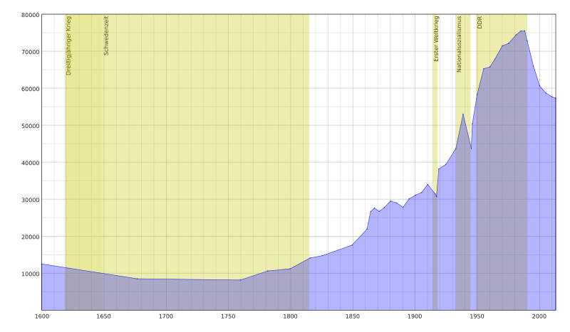
Deutsch: Die Grafik zeigt die Einwohnerentwicklung Stralsunds von 1600 bis 2013. Weiterhin sind einige historische Ereignisse markiert. English: This chart shows the population development of Stralsund from 1600 to 2013. Furthermore some historic events are marked. |
| Date | |
| Source | Own work |
| Author | Benno Waldhauer |
| Camera location | | View this and other nearby images on: OpenStreetMap |
|---|
Licensing[edit]
I, the copyright holder of this work, hereby publish it under the following license:
This file is licensed under the Creative Commons Attribution-Share Alike 4.0 International license.
- You are free:
- to share – to copy, distribute and transmit the work
- to remix – to adapt the work
- Under the following conditions:
- attribution – You must give appropriate credit, provide a link to the license, and indicate if changes were made. You may do so in any reasonable manner, but not in any way that suggests the licensor endorses you or your use.
- share alike – If you remix, transform, or build upon the material, you must distribute your contributions under the same or compatible license as the original.
File history
Click on a date/time to view the file as it appeared at that time.
| Date/Time | Thumbnail | Dimensions | User | Comment | |
|---|---|---|---|---|---|
| current | 22:12, 16 November 2014 | | 1,500 × 875 (82 KB) | Benno.waldhauer (talk | contribs) | User created page with UploadWizard |
You cannot overwrite this file.
File usage on Commons
There are no pages that use this file.
File usage on other wikis
The following other wikis use this file:
- Usage on pl.wikipedia.org